Two Rounds of Severe Storms Target Illinois and Indiana Along I-70 Corridor Thursday With Hail and Tornado Threat Possible
ILLINOIS — Two separate rounds of severe thunderstorms are expected Thursday across Illinois and Indiana, with storms developing along the I-70 corridor and moving east through the afternoon and evening.
Forecasters indicate the first wave will form in Illinois by early afternoon before pushing into Indiana, followed by a second, potentially more dangerous round later in the day if atmospheric recovery allows stronger storms to develop.
Round One: Early Afternoon Hail Threat Across Illinois
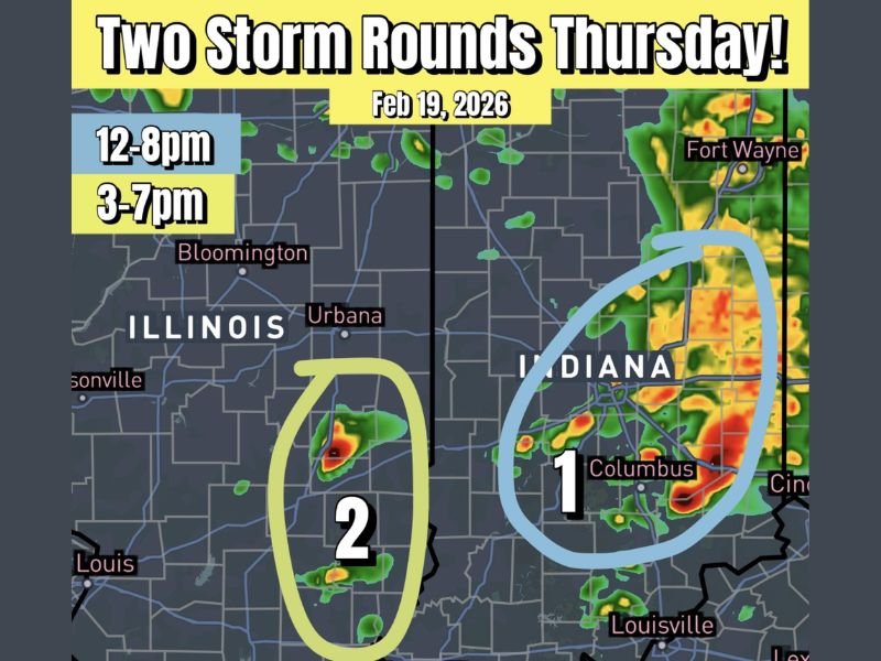
The first round of storms is expected to develop between approximately 12 p.m. and 3 p.m. in Illinois. These storms are forecast to move quickly eastward into Indiana as the afternoon progresses.
Meteorologists say this initial wave will likely feature elevated thunderstorms capable of producing hail. While damaging winds are possible, the primary concern during round one appears to be hail-producing cells. Radar projections show storms forming near central Illinois, including areas around Bloomington and Urbana, before advancing east toward Indiana.
Round Two: Evening Supercells Could Bring Tornado Potential
The second round, expected between 3 p.m. and 7 p.m., carries greater uncertainty but also higher potential severity. Forecasters note that if enough atmospheric recovery occurs behind the first round, discrete supercells capable of producing all severe weather modes could develop. This includes damaging winds, large hail, and an increased tornado threat.
The highest concern for tornado development appears to shift into Indiana during the late afternoon and early evening hours. Storms may intensify near the I-70 corridor and track toward cities including Columbus, with strong radar signatures already modeled in that region . Experts emphasize that tornado potential will depend heavily on how much instability rebuilds after the first wave moves through.
Focus Area: I-70 Corridor in Illinois and Indiana
Both rounds of storms are expected to focus near the Interstate 70 corridor stretching from central Illinois into central Indiana.
Communities from Bloomington and Urbana eastward toward Indianapolis and Columbus could experience multiple rounds of storms. The evening wave, if it materializes as projected, would likely pose the greater severe risk.
Residents are encouraged to monitor updated forecasts throughout the day, especially if traveling along I-70 during peak storm hours.
Timing and Preparedness
Storms are expected to begin as early as midday in Illinois and continue through early evening across Indiana. Meteorologists stress that while not every location will experience severe weather, conditions appear supportive of at least isolated strong to severe storms in both rounds.
Anyone in the affected areas should ensure they have multiple ways to receive weather alerts and be prepared to act quickly if warnings are issued. Severe weather setups involving multiple rounds can evolve rapidly. Forecast details may shift as new data becomes available.
If you have severe weather safety tips or experiences from past storms in Illinois or Indiana, share your thoughts with us at SaludaStandard-Sentinel.com. Community awareness helps everyone stay informed and prepared.