Kentucky Warm-Up Builds for Feb. 17–20 as Forecast Odds Show 50°+ Likely Statewide and Some Areas Eye 60s to Near 70
KENTUCKY — A mid-February warm-up is shaping up across the state, with forecast data showing a strong likelihood that many communities will reach 50 degrees or warmer between February 17–20, 2026, and some spots could push into the 60s or even near 70 later in the week.
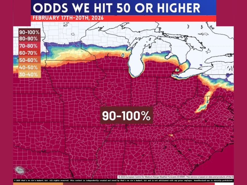
What the Forecast Odds Map Is Signaling
The outlook graphic for Feb. 17–20 highlights a broad region of the central and eastern U.S. with extremely high probabilities of 50°+ temperatures, and Kentucky sits squarely in the highest confidence zone. The map indicates 90–100% odds across much of the region, signaling that this is not a borderline warm-up—it’s the kind of pattern forecasters usually flag as a meaningful temperature shift for late winter.
How Warm It Could Get Later This Week
While 50° readings appear likely across Kentucky, the discussion tied to the outlook suggests a growing chance that warmer air could surge even more aggressively later in the week. That’s where the 60–70 degree potential comes in—especially if clouds break long enough for daytime sun to amplify the warm push.
Even if not every county reaches the upper end of that range, the overall theme is clear: winter cold is expected to loosen its grip for several days.
Gusty and Wet Periods Could Mix In With the Warmth
This warmer pattern may not be perfectly calm. The setup could bring gusty winds at times and periods of rain or wet weather, which is common when a warm air mass moves in and clashes with lingering seasonal chill nearby.
That combination can create rapid swings—mild afternoons followed by damp, breezy conditions that make it feel cooler than the temperature suggests.
What This Means for Roads, Rivers, and Late-Winter Plans
A multi-day warm streak in February can accelerate melting where snow or ice is present and can also lead to ponding water in low spots during rainy periods. It’s also the kind of stretch that gets people outside—so residents should still stay weather-aware if winds increase or showers become heavier.
Are you seeing the warm-up where you live yet, or still stuck in winter air? Share your local temperatures and conditions with SaludaStandard-Sentinel.com and let others know what’s happening in your area.