Florida’s Worst February Drought in 25 Years Deepens as Cities Run 8–13 Inches Behind Rainfall and Fire Season Looms
FLORIDA — Much of the state is locked in what’s being described as the worst February drought in 25 years, with rainfall deficits approaching — and in some cases exceeding — a foot behind normal since early fall.
How Far Behind on Rain Florida Really Is Right Now
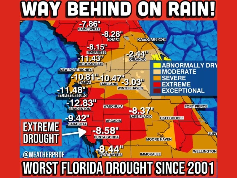
The rainfall shortfall shown across the state is staggering. Several Gulf Coast and central Florida communities are running roughly 8 to 13 inches below normal, including Bradenton (-12.83″), St. Petersburg (-11.48″), Brooksville (-11.43″), and Tampa (-10.81″). Nearby, Lakeland (-10.47″) and Sarasota (-9.42″) remain deeply behind as well.
Even parts of north and central Florida are showing major deficits, including Ocala (-8.28″), Inverness (-8.15″), and Gainesville (-7.86″). Farther south, areas such as Punta Gorda (-8.58″), Fort Myers (-8.44″), and Lake Placid (-8.37″) continue to stand out in drought intensity.
Some locations are not as extreme but are still trending dry, including Orlando (-2.44″) and Winter Haven (-3.03″), which can still create significant stress on landscapes and water supplies over time.
Drought Categories Show Severe to Exceptional Conditions
The drought map indicates broad zones ranging from abnormally dry to moderate, severe, extreme, and even exceptional drought across parts of Florida. That matters because the deeper the drought category, the more likely residents are to notice browning lawns, stressed trees, shrinking ponds, and rising wildfire risk as temperatures climb.
This dryness is also raising concern heading into spring, when brush and vegetation can ignite more easily.
A Possible Inch of Rain Isn’t Enough to Fix the Problem
There is some hope of rainfall — about an inch in spots — but the reality is that a single round of rain won’t erase deficits this large. When communities are 8–13 inches behind, it usually takes multiple widespread rain events over weeks to meaningfully improve drought conditions.
What Residents Should Watch for in the Coming Weeks
With spring approaching, the big worry becomes fire season conditions and quick-burning fuels like dry grass and brush. Residents should stay alert for local burn bans, avoid careless outdoor burning, and keep an eye on changing conditions if winds increase.
Have you noticed dry yards, low water levels, or smoky conditions where you live? Share what you’re seeing and join the conversation at SaludaStandard-Sentinel.com.