Texas Cold Front Set for February 22–23 as Arctic Air Drops South, Raising Freeze Concerns in Hill Country and San Antonio
TEXAS — After a stretch of unseasonably warm days, a new cold front is projected to sweep into the state around February 22–23, pulling down a fresh surge of Arctic air from western Canada and reminding residents that winter is not finished just yet.
Forecast models indicate a noticeable shift in the pattern late next week, with colder air spilling southward through the Plains and into Texas. While this does not appear to be a major winter storm at this time, it does signal a return to below-normal temperatures across parts of the state.
Arctic Air Mass Builds to the North
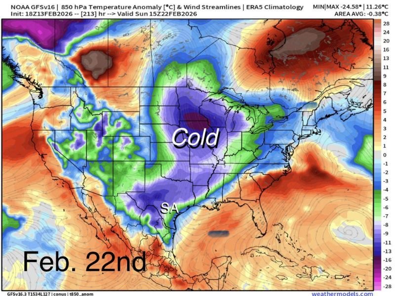
Weather guidance shows a large pool of Arctic cold building in western Canada before breaking southward. By February 22nd, that air mass is expected to push into the central United States and eventually into Texas.
The projected temperature anomaly map highlights a significant area of colder-than-average air spreading through the Plains and into central and southern Texas. This reinforces that the current mild spell is temporary.
San Antonio May Avoid a Hard Freeze
One of the biggest questions residents are asking is whether overnight freezes are still possible. The answer is yes — but the degree of impact may vary by region.
At this point:
- A hard freeze in San Antonio is uncertain.
- The likelihood of freezing temperatures appears higher in the Hill Country.
- San Antonio could see 2–3 nights with lows in the 30s to low 40s.
That range may not be extreme, but it is cool enough to impact early landscaping plans and sensitive plants.
Not Time to Fully Commit to Spring Planting
With temperatures rebounding recently, many Texans have been wondering whether winter is essentially over. Forecasters caution that it is still February, and additional cold fronts remain possible.
While this particular front may not bring widespread freeze conditions to major metro areas, it reinforces that cold snaps can still occur before the official start of spring. Gardeners and landscapers may want to hold off on putting new plants into the ground just yet. Potted plants can be moved more easily if temperatures dip lower than expected.
Winter Not Dead Yet
Even though daytime highs have recently climbed into comfortable territory, seasonal patterns suggest more fluctuations are likely. The expected front around the 22nd–23rd is one of several potential systems that could still move through before winter fully transitions.
For now, Texans can enjoy the warmth — but should keep an eye on the forecast as late February approaches. Stay with SaludaStandard-Sentinel.com for continued updates as models refine the details of this incoming cold front.