MICHIGAN 10-Day Warm Stretch Brings Highs Into the 40s as Forecast Shows +7° to +15° Above Average and No Major Arctic Outbreak in Sight
MICHIGAN — The next 10 days across the state are shaping up to feel noticeably milder than typical mid-February standards, with near- to above-average temperatures dominating and no immediate signs of a major Arctic blast returning.
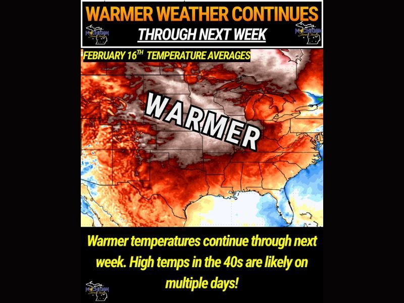
A new temperature anomaly outlook shows widespread orange and red shading over much of the Midwest, including Michigan. On these maps, warmer colors represent above-average temperatures, while blues and greens indicate below-average readings. In this case, Michigan is firmly in the warmer category.
What the Temperature Anomaly Map Shows
Forecasters are seeing projected anomalies of +7 to +15 degrees above average for this time of year. In practical terms, that means afternoon highs frequently reaching:
- Upper 30s
- Lower to mid-40s
- Possibly multiple days solidly in the 40s
For mid-February in Michigan, those readings are comfortably above seasonal norms.
Instead of deep freezes and prolonged sub-zero wind chills, the pattern favors a relatively mild stretch. While it is still winter, the harshest edge of the season appears to be fading — at least temporarily.
No Immediate Arctic Air Return
One of the key takeaways from this outlook is the absence of any strong Arctic air intrusions in the short term. Meteorologists note there are no imminent signs of another major cold outbreak in the coming week and a half.
That does not mean winter is officially over. February can still deliver quick cold shots, and long-range forecasting always carries uncertainty. However, the data currently suggests that any colder push arriving later in the month would likely be:
- Short-lived
- Less intense than earlier outbreaks
- Not prolonged in nature
Could Colder Air Arrive Later in February?
There are early indications that another wave of colder air may try to move in around the 20th of the month, but confidence remains low at this stage.
Forecast models vary on how strong that system could be and whether it would bring significant temperature drops. As of now, meteorologists emphasize that:
- There is major uncertainty in that timeframe
- A prolonged Arctic outbreak looks increasingly unlikely
- Any cold snap would probably be brief
What This Means for Michigan Residents
For now, the trend favors:
- Milder winter afternoons
- Easier travel conditions
- Less strain from prolonged deep freezes
Snow and ice events remain possible, as winter systems can still develop in a warmer pattern. But compared to earlier in the season, the atmosphere appears less supportive of extended brutal cold. The overall message: enjoy the relative break while it lasts.
Michigan is not quite done with winter yet — but for the next 10 days, it appears the state will stay on the warmer side of the seasonal spectrum. For continued updates on regional weather trends and developing temperature patterns, stay connected with SaludaStandard-Sentinel.com.