Texas Severe Storm Outlook Expands Toward I-35 Corridor as SPC Flags Friday–Sunday Threat from Val Verde County to Dallas–Fort Worth and Houston
TEXAS — The Storm Prediction Center (SPC) has updated its severe weather outlook for Friday into early Saturday, and while the primary risk remains west of the I-35 corridor for now, parts of Texas are back on alert as the weekend approaches.
The latest outlook still clips Val Verde County, but much of the highlighted risk area currently sits west of major metro zones. However, forecasters are closely monitoring a developing setup that could shift east and expand into more populated regions by Saturday into early Sunday.
Friday–Early Saturday: West Texas in the Spotlight
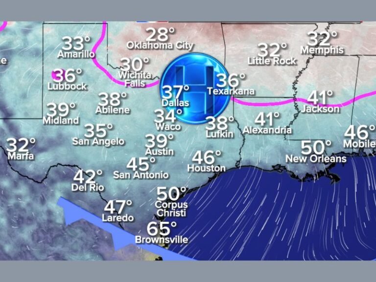
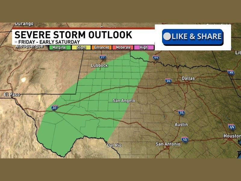
The updated map shows a Marginal Risk (Level 1 of 5) stretching from far southwest Texas northeastward across portions of West Texas, including areas near:
- Del Rio
- San Angelo
- Lubbock
- Surrounding counties along and west of I-27
This level typically indicates isolated severe storms are possible, with primary threats including:
- Gusty damaging winds
- Small hail
- Brief heavy downpours
At this time, the bulk of the outlook does not directly include Dallas–Fort Worth, Austin, San Antonio, or Houston. But that may not hold through the weekend.
Day 3 Outlook: I-35 Corridor Could Enter the Picture
Forecasters note that the Day 3 severe outlook covering Saturday into early Sunday could expand farther east.
Given the evolving atmospheric pattern, meteorologists expect at least some form of severe risk to extend:
- Northward along I-35
- Into the Dallas–Fort Worth Metroplex
- Potentially into parts of the Houston area
That updated outlook is expected later tonight, and confidence in placement will increase once additional model data becomes available.
What’s Driving the Setup?
While detailed upper-level dynamics are still being refined, the general ingredients appear to include:
- Increasing Gulf moisture
- A strengthening disturbance moving across the Southern Plains
- Adequate instability building through Saturday
If these elements align more aggressively eastward, storms could intensify along the dryline and then push toward more populated areas.
However, track and timing remain somewhat uncertain, which is why current risk levels remain on the lower end.
What Residents Should Know
For now:
- West Texas faces the primary Friday risk.
- Central and North Texas should monitor updates for Saturday.
- Houston and southeast Texas may see increasing chances late Saturday into Sunday if the system trends eastward.
It is too early to determine exact storm intensity or coverage for metro areas, but this is the kind of evolving setup that can change within 24–36 hours.
Residents are encouraged to review severe weather safety plans, especially as we move into peak spring storm season across Texas. We will continue monitoring updates from the Storm Prediction Center and regional forecast offices as the weekend threat becomes clearer.
Stay informed with timely severe weather updates and regional coverage at SaludaStandard-Sentinel.com as we track this developing Texas storm system through the weekend.