Florida’s Tampa Bay Region Faces Near-Zero Visibility Thursday Morning as Widespread Fog and ‘Super Fog’ Threat Looms
FLORIDA — Drivers across the Tampa Bay region are being urged to set their alarms early Thursday as widespread dense fog is expected to dramatically reduce visibility, potentially creating dangerous travel conditions during the morning commute.
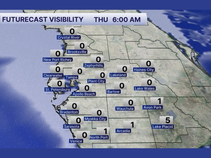
Forecast data for Thursday at 6:00 AM shows visibility dropping to near zero miles in multiple cities, including Tampa, St. Petersburg, Clearwater, Brooksville, Crystal River, Lakeland, Zephyrhills, Plant City, Bartow, Bradenton, and Sarasota. Several areas are projected to report 0-mile visibility, meaning drivers could encounter whiteout-like conditions on roadways.
Near-Zero Visibility Across Major Cities
The forecast map highlights widespread fog coverage stretching from the Gulf Coast inland through central Florida communities:
- Tampa – 0 miles
- St. Petersburg – 0 miles
- Clearwater – 0 miles
- Brooksville – 0 miles
- Lakeland – 0 miles
- Plant City – 0 miles
- Bartow – 0 miles
- Bradenton – 0 miles
- Sarasota – 0 miles
Further south and east, visibility may improve slightly but will still be limited:
- Arcadia – 1 mile
- North Port – 1 mile
- Avon Park – 1 mile
- Lake Placid – 5 miles
While Lake Placid may see somewhat better conditions, much of the region will likely experience dangerously low visibility during peak travel hours.
Brush Fire Season Raises ‘Super Fog’ Concerns
Forecasters are also highlighting another risk tied to Florida’s seasonal conditions: “Super Fog.” This phenomenon occurs when fog mixes with smoke from brush fires, creating an even denser and more hazardous visibility situation.
With brush fire season underway across parts of Florida, the combination of high humidity overnight and lingering smoke particles can make fog thicker and more unpredictable. Super Fog events can develop rapidly and catch drivers off guard, especially along rural highways and low-lying areas.
What Drivers Should Expect Thursday Morning
The worst conditions are expected in the pre-dawn and early morning hours, around 6:00 AM, before gradual improvement later in the day as temperatures rise and sunlight helps dissipate the fog.
Motorists are encouraged to allow extra travel time, use low-beam headlights instead of high beams, increase following distance, and remain alert for sudden drops in visibility. Conditions may vary significantly from one neighborhood to the next, meaning drivers could move from clear skies into dense fog within minutes.
While fog events are common in Florida, the widespread nature of this system combined with potential smoke concerns makes Thursday morning’s setup particularly noteworthy. Residents across Tampa Bay, Lakeland, Sarasota, and surrounding communities should monitor updates and plan accordingly. Even short commutes could become hazardous under near-zero visibility conditions.
If you are experiencing dense fog in your area Thursday morning, share your updates and travel conditions with us. Stay connected for continuing weather coverage and local alerts at SaludaStandard-Sentinel.com.