Pennsylvania Begins Gradual Warm-Up After Arctic Weekend as Light Wintry Mix Threatens Eastern Areas Tuesday Night
PENNSYLVANIA — After a harsh Arctic blast over the weekend, Pennsylvania is finally beginning a slow climb out of deep winter cold. While Monday remains chilly across much of the state, temperatures are expected to steadily improve, with the warmest air arriving Tuesday, particularly across western and central regions.
Cold Start Monday but Clear Signs of a Temperature Rebound
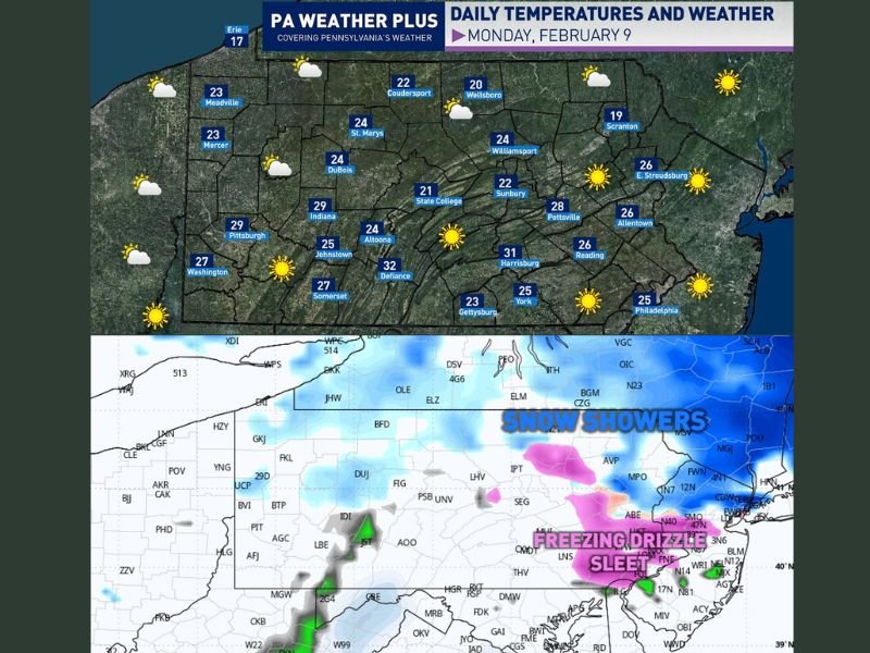
Monday will still feel cold statewide, with afternoon highs generally reaching the 20s under partly to mostly sunny skies. Despite the cold, this marks the start of a recovery period following the weekend’s Arctic conditions. Winds will be lighter, and sunshine will help temperatures edge upward compared to recent days.
Tuesday Brings Peak Warmth to Western and Central Pennsylvania
The warming trend is expected to peak Tuesday, with highs climbing into the 40s across much of western and central Pennsylvania. This will be the most noticeable temperature improvement many areas have seen in several days and should feel significantly more comfortable compared to the weekend.
Eastern Pennsylvania Likely to Miss Out on the Warmest Air
Eastern Pennsylvania is not expected to warm as efficiently. Colder air trapped near the surface east of the Appalachian Mountains will likely keep temperatures lower than points farther west. While some warming is still expected, highs may fall short of the 40s in several eastern communities.
Light Snow and Wintry Mix Possible Tuesday Evening Into Overnight
Forecasters are also monitoring a weak disturbance moving through the region Tuesday evening into the overnight hours. This system may provide enough moisture to generate light snow showers, along with a few pockets of freezing drizzle or sleet, especially across eastern and northeastern Pennsylvania.
Minor Travel Concerns Possible After Tuesday Evening Commute
At this time, any wintry precipitation is expected to be light, but it could still create minor travel concerns, particularly after 5 PM Tuesday and into the night. Even small amounts of snow or ice can cause slick spots on untreated roads, bridges, and overpasses.
No Major Storm Signals but Winter Is Not Finished
There are currently no indications of a major winter storm associated with this system. However, the pattern highlights the continued back-and-forth nature of February weather, with warming periods followed by brief disruptions. Residents are encouraged to stay aware of forecast updates as details become clearer.
Pennsylvania’s transition away from Arctic cold is underway, but winter still has a presence — especially in eastern parts of the state. For continued weather coverage and regional updates, visit SaludaStandard-Sentinel.com.