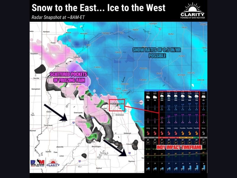
Indiana Faces Tricky Friday Morning Commute as Indianapolis Area Splits Between Snow to the East and Freezing Rain to the West
INDIANA — Central Indiana commuters could be in for a difficult Friday morning as mixed precipitation spreads across the region, with forecast graphics showing a clear split: snow to the east of Indianapolis and scattered pockets of freezing rain to the west, creating a travel setup that can change quickly mile by mile.
Snow to the East of Indianapolis With Heavier Rates Possible
The forecast map highlights a broad snow shield across eastern and northeastern portions of the state, with a callout noting snow rates of up to 0.5 inches per hour are possible in parts of the snow band.
For drivers east of the Indianapolis metro, that kind of rate can coat roads quickly—especially during the early commute window when surface temperatures are still cold and treatment may struggle to keep up in heavier bursts.
Freezing Rain Pockets to the West Create Hidden Slick Spots
To the west and southwest of Indianapolis, the map shows scattered pockets of freezing rain, which can be more dangerous than snow because it can turn roads and bridges glossy in a short time without looking as dramatic.
Those pockets appear spread across areas west of the metro, with icing potential shown in pink and mixed zones crossing portions of western central Indiana. Even light freezing rain can cause sudden spin-outs, especially on ramps, overpasses, and untreated side streets.
Why the Friday Morning Commute Could Be the Most Problematic
The post tied to the graphic warns that the Friday AM commute for Central Indiana could be “a bit tricky” due to the mixed precip setup. The map also highlights an “Indy impact timeframe”, suggesting the most meaningful travel impacts are expected in the morning hours as the precipitation shield passes through.
The problem in these setups is not always total accumulation—it’s how quickly conditions can deteriorate when snow bursts or freezing rain pockets line up with peak traffic.
Temperatures Expected to Rise Above Freezing Later Friday
One encouraging note in the update is that temperatures are expected to climb above freezing later in the day, which should help melting and improve conditions after the morning window. That means the worst travel risk may be concentrated early, with gradual improvement possible as temperatures rise and road crews catch up.
What Drivers in Indiana Should Watch For
Even within the same county, precipitation type can flip between snow, sleet, or freezing rain depending on elevation and temperature. The most important thing Friday morning will be watching for rapidly changing road conditions, especially near the transition zone around Indianapolis where snow and ice risks overlap.
Are you near Indianapolis or elsewhere in Indiana—are you seeing snow, sleet, or freezing rain where you live? Share what’s happening in your area and keep following updates at SaludaStandard-Sentinel.com.