Texas, Louisiana, Mississippi, Alabama, Georgia, and South Carolina Could See More Storm Activity Feb. 13–18 as Pattern Shifts
UNITED STATES — A weather pattern change expected to take shape next week is raising early concern for increased storm activity from the Gulf Coast into parts of the Southeast, with the Feb. 13–18 window now being watched for a more “storm-friendly” setup.
What’s Changing in the Pattern Next Week
The outlook points to West Coast troughing re-establishing itself, a shift that often helps kickstart a more active storm track downstream. At the same time, forecasters note moisture increasing ahead of the change, a combination that can make conditions feel more springlike and, in some cases, more conducive to stronger storms.
Even without a specific “storm day” locked in yet, the broader concern is that the background environment becomes more favorable for repeated systems to move through.
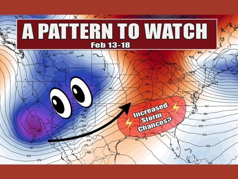
Where Storm Chances May Increase Feb. 13–18
The pattern graphic highlights a zone of increased storm chances centered over parts of the South and lower Mississippi/Tennessee Valley region, which can often include portions of Texas, Louisiana, Mississippi, Alabama, and Georgia as systems develop and track east.
Because these setups can expand with time, forecasters typically watch how far east the more active storm corridor reaches, including whether storms maintain strength as they move toward South Carolina.
Why Forecasters Mention “Springlike” Ingredients
When moisture surges north and the jet stream pattern becomes more energetic, storms can organize more efficiently. That does not automatically mean severe weather will occur, but it does increase the odds of more frequent rounds of rain and thunderstorms, and it’s why forecasters often start highlighting the pattern before the first high-confidence storm system is identified.
What to Watch Now and What Still Isn’t Certain
This is still an early heads-up. The key unknowns are timing, storm track, and how much instability actually builds when each system arrives. As the Feb. 13–18 window gets closer, the focus will sharpen on which states see the highest thunderstorm coverage and whether any round has the ingredients for stronger storms.
If you’re in the Southeast, are you already noticing a warmer, more humid trend setting up ahead of next week? Share what you’re seeing, and keep following updates at SaludaStandard-Sentinel.com.