Another Polar Vortex Disruption Could Split the U.S. in Mid-February, Bringing West Coast Warmth and Sharper Cold to the East
UNITED STATES — Forecast guidance for early to mid-February is pointing toward another polar vortex disruption developing within the next 10 to 14 days, a pattern that could sharply divide the country between above-normal warmth in the West and colder-than-normal conditions across the East as the month continues.
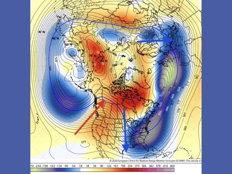
What the Latest Forecast Data Is Showing
The latest atmospheric outlook highlights warming over the polar regions, clearly visible in red shading on upper-level forecast maps. This warming is a key signal that can weaken or displace the polar vortex. When that happens, the jet stream often becomes more amplified, allowing cold Arctic air to plunge southward into the eastern United States while warmer air surges northward across the West.
This setup does not produce uniform cold nationwide. Instead, it favors extremes — with some regions turning unusually mild while others experience deeper-than-normal cold.
Why Forecasters Say the U.S. Could Be “Split in Half”
The current pattern favors a strong ridge of high pressure over the western United States, locking in warmer-than-average temperatures. At the same time, a persistent trough over the eastern half of the country opens the door for repeated cold air intrusions from Canada.
When this west-east split develops, temperature differences across the country can be dramatic. Western states may see extended stretches of mild or even spring-like weather, while the Midwest, Northeast, and Southeast cycle through colder air masses and sharp temperature drops.
Early February Outlook Shows a Clear Temperature Divide
Forecast temperature guidance for the February 6–11 period reinforces this contrast. Much of the West is projected to remain above normal, while large portions of the eastern U.S. are shaded for below-normal temperatures. A narrow zone across the central states appears closer to seasonal averages, though even those areas could see rapid swings as storm systems pass through.
This pattern supports the idea that February will not be consistently cold everywhere, but overall colder than normal for the eastern half of the country.
What This Means for the Southeast and South Carolina
For the Southeast — including South Carolina and surrounding states — this type of setup often brings brief warm spells followed by sudden cold snaps. Strong cold fronts, gusty winds, and overnight freezes become more likely as colder air repeatedly pushes southward. Even when daytime temperatures rebound, nights can turn sharply colder under clear skies and Arctic air masses.
Why the Next 10–14 Days Matter
Because this potential disruption is still more than a week away, the exact timing and intensity can still change. However, the signal for a colder eastern pattern is strong enough that residents should closely monitor updated forecasts. Travel plans, outdoor work, agriculture, and infrastructure could all be affected if colder air becomes more persistent.
Are you already seeing unusual temperature swings in your area or preparing for another cold stretch? Share your experience and stay connected with continued weather coverage at SaludaStandard-Sentinel.com.