Prolonged Freezing Rain Targets South Carolina Upstate as High-Resolution Data Shows Significant Ice Accumulation Through Sunday Evening
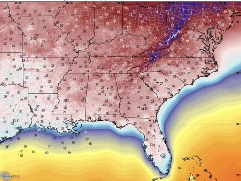
SOUTH CAROLINA — New high-resolution forecast data indicates that the South Carolina Upstate is facing a long-duration freezing rain event, with ice remaining the dominant precipitation type for nearly the entire storm. Unlike surrounding regions that may see temperature moderation, the Upstate is expected to stay locked below freezing, setting the stage for dangerous travel and widespread power disruption.
Meteorologists say this setup favors significant ice accumulation, especially across northern Upstate counties, where freezing rain may persist for more than 18 hours. Ice is expected to begin late this evening and may not fully end until around 5:00 p.m. Sunday, creating an extended period of hazardous conditions.
Conditions west of Asheville and into the higher elevations of the southern Appalachians may fare better, as warmer air aloft and weaker northeast cold-air influence could keep temperatures near or just above freezing at times. For the Upstate, however, the story is much different.
Freezing Rain Dominates the Upstate
Forecast guidance shows precipitation falling almost entirely as freezing rain across the Upstate, with only a brief window for sleet early in the event. As freezing rain continues hour after hour, ice will steadily accumulate on roads, trees, and power lines.
The highest ice totals are expected across northern Pickens County, Oconee County, and Greenville County, where ice accretion could exceed one inch in some locations.
Farther south, including areas along and south of Interstate 85 into Greenwood, ice amounts closer to one-half inch are still likely — more than enough to cause severe impacts.
Travel and Power Outage Risks Increasing
Ice amounts of this magnitude significantly increase the risk of tree damage, downed power lines, and prolonged power outages. Even a quarter inch of ice can cause issues, but half an inch or more greatly raises the threat of infrastructure failure.
Road conditions are expected to deteriorate quickly once freezing rain begins, with bridges and elevated surfaces becoming icy first. As ice builds, travel may become extremely dangerous or impossible across much of the Upstate.
Timeline and What to Expect
Freezing rain is expected to begin late tonight, intensify overnight, and persist through much of Sunday afternoon. The long duration under freezing temperatures is the primary concern, allowing ice to accumulate without melting.
This is a high-impact winter weather setup, not a brief icing event. Residents should prepare now for the possibility of extended outages, avoid unnecessary travel, and ensure emergency supplies are ready.
Further updates will continue as the storm evolves. Stay with SaludaStandard-Sentinel.com for ongoing coverage, local impact updates, and safety information as this dangerous ice storm unfolds across the Upstate.


