Texas, Arkansas, Mississippi, Tennessee, Alabama, Georgia, South Carolina, North Carolina, Kentucky, West Virginia, and Virginia Face a Prolonged, High-Impact Ice and Sleet Storm With Crippling Travel and Power Risks
SOUTHERN AND EASTERN UNITED STATES — A long-duration winter storm is increasingly likely to bring dangerous ice and sleet accumulation across a broad corridor stretching from northeast Texas through the Deep South and into the Carolinas and Appalachians, with impacts unfolding from Friday night through Sunday evening.
Latest hurricane-hunter-assisted model data continues to trend toward higher ice totals, a wider sleet corridor, and longer-lasting impacts, raising serious concerns for power outages, road closures, and near-impossible travel across multiple states.
Storm Setup: Why This Event Is So Dangerous
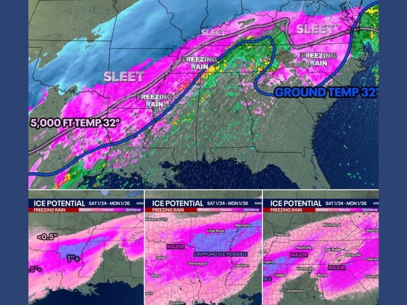
This storm is being driven by a strong surge of warm air aloft overriding shallow arctic air at the surface, a classic setup for freezing rain and heavy sleet instead of snow.
While forecast radar graphics often show broad “pink” areas, not all pink precipitation is equal. In this case, the data clearly separates zones of freezing rain from zones of heavy sleet, each with very different impacts.
Key atmospheric features include:
- Sub-freezing ground temperatures
- Warm air above 5,000 feet
- Cold air damming (CAD) east of the Appalachians
- A slow-moving system, allowing impacts to last up to 48 hours
Areas at Highest Risk for Crippling Ice
Model consensus shows the greatest threat of damaging freezing rain across:
- Northeast Texas
- Southern and central Arkansas
- Northwest Mississippi
- Southwest and central Tennessee
- Interior Alabama
- Interior Georgia
- Interior South Carolina
- Interior North Carolina
In these regions, significant ice accretion could:
- Down trees and power lines
- Cause widespread, multi-day power outages
- Make roads impassable, even for emergency vehicles
Heavy Sleet Corridor: Loud, Intense, and Long-Lasting
North of the freezing rain zone, a corridor of extreme sleet accumulation is increasingly likely from:
- Central Arkansas
- Western and central Kentucky
- West Virginia
- Western and central Virginia
Some locations may experience hours of continuous heavy sleet, described in the data as:
- Inches of sleet accumulation
- Sleet striking surfaces like rocks against windows
- Extremely slow melting due to sleet’s high water content
While sleet is less destructive to power infrastructure than freezing rain, it can still:
- Make roads nearly impossible to clear
- Create concrete-like ice layers
- Cause prolonged travel shutdowns
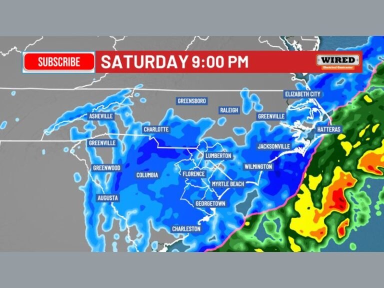
Timing: When Conditions Deteriorate
Friday Night
- Precipitation begins developing from west to east
- Initial rain transitions to freezing rain or sleet
Saturday
- Widespread heavy ice and sleet
- Travel rapidly becomes dangerous or impossible
- Power outages likely begin
Saturday Night into Sunday
- Peak impacts
- Continued ice accretion
- Little to no melting due to sustained cold
Sunday Evening
- Gradual tapering from west to east
- Lingering hazardous conditions continue
Travel and Infrastructure Impacts
Forecast impact maps show a large, continuous zone of high winter-storm impact, indicating:
- Widespread flight cancellations
- Interstates and secondary roads impassable
- Emergency response delays
- Long-duration infrastructure stress
Travel is strongly discouraged across the affected states through the weekend.
Why Snow Totals Will Be Lower Than Expected
As sleet and freezing rain push farther north, snow totals will be reduced in many areas that might normally see snow. This does not reduce risk—in fact, it increases danger, as ice impacts are typically more severe than snow.
Bottom Line
This is shaping up to be a high-impact, long-duration winter storm, dominated by freezing rain and heavy sleet, not snow. The combination of ice accumulation, prolonged cold, and extended duration makes this event especially dangerous across Texas, Arkansas, Mississippi, Tennessee, Alabama, Georgia, South Carolina, North Carolina, Kentucky, West Virginia, and Virginia.
Residents should complete preparations early, avoid travel, and plan for possible power outages lasting days, not hours. Stay alert for updates as the exact freezing-rain and sleet boundaries will continue to be refined as the storm approaches.