Texas, Oklahoma, Arkansas, Louisiana, Mississippi, Alabama, Tennessee, Kentucky, Georgia, the Carolinas, Virginia, and the Northeast Face a High-Impact, Nearly 48-Hour Winter Storm With Travel Not Advised
UNITED STATES — A massive winter storm is expected to impact a broad swath of the central and eastern United States from Saturday through Sunday, with dangerous travel conditions, widespread flight cancellations, and prolonged heavy precipitation expected across multiple regions. Forecast impact maps show extreme disruption potential stretching from Texas and the Southern Plains through the Ohio Valley, Southeast, Mid-Atlantic, and into the Northeast.
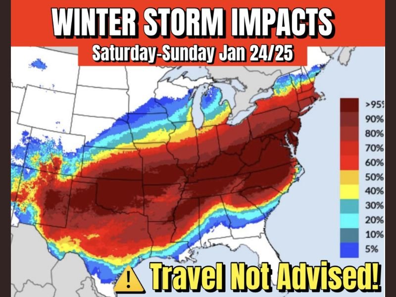
A Rare, Coast-to-Coast Scale Impact Zone
The latest impact map highlights an unusually large and continuous corridor of high winter-storm impact, covering:
- Texas, Oklahoma, and Arkansas
- Louisiana, Mississippi, Alabama, and Tennessee
- Kentucky and the Ohio Valley
- Georgia, South Carolina, and North Carolina
- Virginia, the Mid-Atlantic, and the Northeast
Much of this region falls within the highest impact categories, indicating severely degraded road conditions, limited emergency response capability, and significant disruption to normal travel and commerce.
Travel Strongly Discouraged Saturday and Sunday
Forecasters are urging residents across the affected states to cancel or rearrange travel plans, warning that road travel may become nearly impossible in many areas during the height of the storm.
Air travel is also expected to be heavily impacted, with numerous flight delays and cancellations likely due to runway icing, snow accumulation, and prolonged periods of wintry precipitation at major hubs.
Heavy Precipitation Regardless of Type
One of the most dangerous aspects of this system is that impacts will be severe regardless of precipitation type. Whether locations experience:
- Snow
- Freezing rain
- Sleet
- Or a combination of all three
The precipitation is expected to be heavy, long-lasting, and efficient, with many areas seeing continuous impacts for nearly 48 hours. Prolonged duration dramatically increases risks for ice buildup, road deterioration, power disruptions, and emergency response delays.
Long-Duration Event Raises Risk Levels
Unlike fast-moving winter systems, this storm is expected to stall and evolve over the same regions, compounding impacts over time. Even areas that begin as rain or snow may transition to freezing rain or sleet, worsening conditions late in the event.
This extended timeline significantly raises the likelihood of:
- Widespread road closures
- Stranded motorists
- Supply chain disruptions
- Power outages in ice-prone regions
Bottom Line: A Major, Multi-Day Winter Storm With Nationwide Implications
This is not a localized winter weather event. The data clearly shows a large-scale, high-impact storm affecting more than half the country, with Saturday and Sunday posing the greatest risk.
Residents across the impacted states should avoid unnecessary travel, prepare for prolonged disruptions, and closely monitor updates as the storm unfolds. Stay with SaludaStandard-Sentinel.com for continued, map-verified winter storm coverage, impact updates, and safety guidance as conditions evolve.