Michigan Braces for Back-to-Back Clipper Systems as Two-Phase Snow Event Brings Hazardous Travel, Blowing Snow, and Lake-Effect Accumulations
MICHIGAN — A closely spaced pair of winter weather systems is expected to impact much of Michigan from Wednesday morning through Thursday afternoon, creating a two-phase snow event that could significantly disrupt travel, especially during the Wednesday morning commute and again Wednesday night into early Thursday.
Two Clipper Systems Driving a Prolonged Snow Event
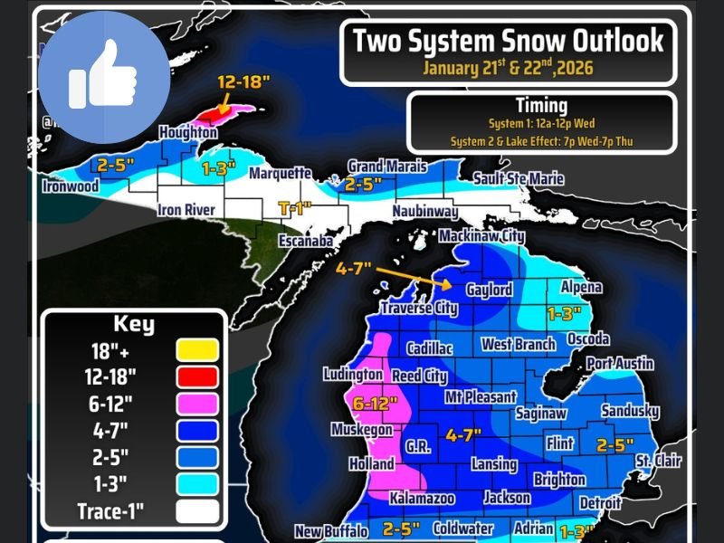
Meteorologists say the overall snowfall forecast reflects two separate clipper systems passing through Michigan in rapid succession. The first system arrives early Wednesday, followed by a brief lull, before the second and more impactful system moves in Wednesday night with stronger winds.
Because the systems pass so close together, final snowfall totals combine impacts from both rather than representing a single burst of snow. In most areas, totals are expected to be evenly split between the two systems, though wind-driven snow with the second system may create greater impacts despite similar accumulation.
Timing Breakdown Highlights Commute and Overnight Risks
System One is expected between midnight and noon Wednesday, with the highest snowfall rates during the morning commute, affecting both main roads and secondary streets.
System Two follows between 7 p.m. Wednesday and 7 p.m. Thursday, with the most intense snowfall occurring overnight into early Thursday morning. Strong wind gusts could reach up to 40 mph, leading to snow squalls and near-blizzard conditions, especially along major highway corridors.
Blowing Snow and Near-Blizzard Conditions Possible
The second system brings increased concern due to strong winds combining with falling snow, particularly along the I-96 and I-94 corridors from Lake Michigan toward Metro Detroit. Reduced visibility, drifting snow, and rapidly deteriorating road conditions could make nighttime travel extremely dangerous.
Meteorologists warn that even areas with moderate snowfall totals may experience whiteout-like conditions due to blowing snow.
Lake-Effect Snow Adds to Totals in Northern Michigan
In addition to the clippers, lake-effect snow will persist throughout the entire event, especially across the Keweenaw Peninsula, where around 12 inches of additional snow is likely by Thursday afternoon.
Lake-effect bands may also enhance snowfall in parts of western and northern Lower Michigan, adding to totals and prolonging hazardous travel conditions beyond the main systems.
Freezing Drizzle Risk South of US-10
South of US-10, slightly warmer temperatures raise the risk of freezing drizzle, particularly on Wednesday. Even where snowfall totals remain modest, roads may develop a thin glaze of ice, sharply increasing accident risk.
Forecasters note that drier air near the US-12 border region may limit snowfall amounts there, though slick road conditions are still possible.
Travel Disruptions Expected Across Key Highways
The greatest travel delays are expected along and west of US-131, across all of I-96, and potentially along I-94 from Benton Harbor to Jackson. Emergency managers urge drivers to plan for slow travel, sudden visibility drops, and rapidly changing road conditions, especially overnight.
Residents Urged to Stay Alert as Conditions Evolve
While snowfall amounts may shift slightly as the systems approach, meteorologists stress that the impact threat is already clear. The combination of two systems, strong winds, lake-effect snow, and pockets of ice creates a high-confidence hazardous travel setup.
Residents are encouraged to monitor updates, limit unnecessary travel during peak impact periods, and allow extra time for commutes. How are conditions shaping up in your area, and are you adjusting travel plans ahead of this two-system event? Share your experience and observations with the SaludaStandard-Sentinel.com community.