Alabama, Georgia, Tennessee, and the Carolinas Could See Rare Sunday Snow as Forecast Models Push Winter Storm Deeper Into the South
SOUTHEASTERN UNITED STATES — New forecast data is raising concern across the Deep South after updated weather models showed a growing chance of snowfall stretching from Alabama through Georgia, Tennessee, the Carolinas, and possibly into northern Florida by Sunday.
While the event remains several days away, meteorologists say the consistency of the trend across multiple model runs is what makes this setup notable, especially for regions that rarely experience accumulating snow.
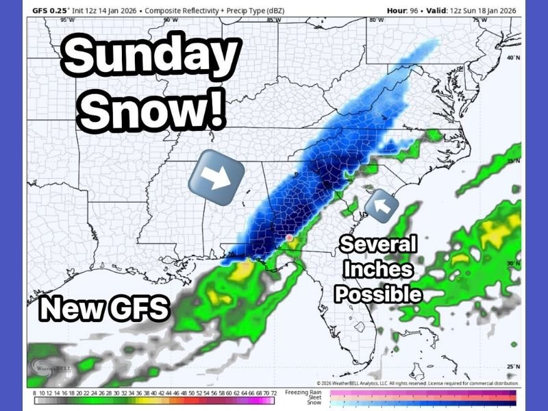
New GFS Run Aligns With Overnight Snow Trends
The latest Global Forecast System (GFS) run closely matches overnight guidance, showing a more organized snow band developing across the Deep South. In parts of the region, the model even hints that several inches of snow could be possible, depending on storm track and temperature profiles. This alignment with previous runs reduces the likelihood that the signal is random or transient, increasing confidence that winter weather is attempting to push farther south than usual.
European Model First Flagged the Threat
The European weather model initially introduced the idea of snow near the Southeast coastline earlier this week. Since then, additional guidance has shown the snow axis expanding northwest, suggesting a broader inland impact zone. Forecasters say this shift is important because it brings interior portions of Alabama, Georgia, Tennessee, and the Carolinas into play, rather than limiting impacts to coastal or elevated areas.
Why Meteorologists Are Taking This Seriously
Although the system is still about four to five days out, winter forecasting relies heavily on pattern recognition. In this case, the pattern continues to favor colder air pressing southward while moisture moves in from the Gulf, a combination that can support snowfall even in typically warmer states.
Meteorologists caution that exact totals, locations, and precipitation type will change, but emphasize that the overall trend is no longer being dismissed as noise.
States That Should Monitor Closely
If the current forecast trajectory holds, areas that could be impacted include:
- Alabama
- Georgia
- Tennessee
- North Carolina
- South Carolina
- Northern Florida
The potential inclusion of Florida underscores how unusual this setup is and why forecasters are urging residents not to ignore early signals.
What Residents Should Do Now
This is not a confirmed snow forecast, and no specific impacts are guaranteed at this stage. However, residents across the Southeast should stay aware, especially those with travel plans late in the weekend. Small changes in temperature or storm track could mean the difference between cold rain and accumulating snow, particularly overnight into Sunday.
The Saluda Standard-Sentinel will continue monitoring forecast updates and provide clearer guidance as confidence improves. Do you think winter still has unfinished business in the South, or will this system fade away? Share your thoughts and stay updated with SaludaStandard-Sentinel.com as the forecast evolves.