South Dakota, Minnesota, Wisconsin, Iowa, Illinois, and Michigan Prepare for Prolonged Snow Event With Accumulations and Travel Impacts Thursday Through Saturday
SOUTH DAKOTA — A prolonged clipper system is expected to move across the Upper Midwest later this week, bringing persistent accumulating snow from Thursday night through Friday, with lingering snow showers possible into Saturday for areas east of the Plains. Forecast data shows a broad swath of 2 to 4 inches of snowfall, with isolated higher totals in some locations. While warmer temperatures ahead of the system may initially delay travel impacts, forecasters warn that arctic air will surge in shortly after snowfall begins, allowing snow to quickly stick to roads and surfaces.
Timing and Snowfall Breakdown
The majority of accumulation is expected to occur Thursday night into Friday, when snowfall rates increase and colder air locks in. Scattered snow showers may continue into Saturday, especially across the eastern portions of the region.
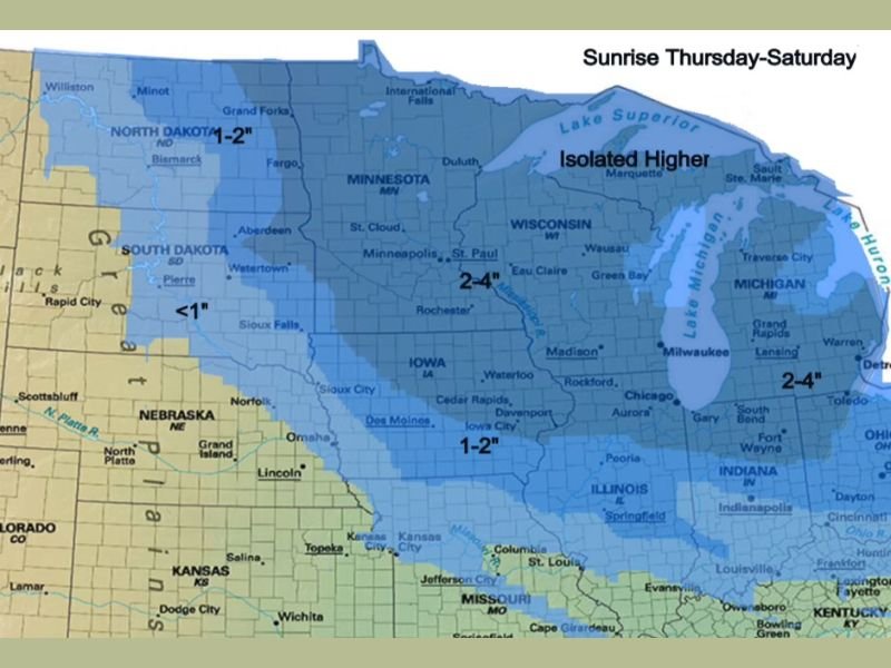
Forecast accumulation ranges include:
- South Dakota and southern Minnesota: generally 1–2 inches, with lighter amounts west
- Central and eastern Minnesota, Wisconsin, and Michigan: widespread 2–4 inches
- Northern Wisconsin and Upper Michigan: isolated higher totals possible
Travel Conditions Expected to Deteriorate
Although roads may remain manageable early Thursday evening, conditions are expected to rapidly deteriorate overnight as temperatures fall and snowfall intensifies. Forecasters say the most hazardous travel window will run from midnight Thursday night through midnight Friday night, when snow-covered roads and reduced visibility become more widespread. Some blowing snow is also possible, which could further lower visibility and worsen driving conditions across open and rural areas.
Why Impacts May Be Worse Than Totals Suggest
Meteorologists caution that even modest snowfall totals can create significant problems when paired with rapidly dropping temperatures. The incoming arctic air mass will cause snow to bond quickly to road surfaces, increasing the risk of icy and slick conditions. This setup raises concerns for overnight travelers, early morning commuters, and freight traffic, particularly along major interstate corridors across the Upper Midwest.
What Residents Should Prepare For
Drivers are urged to plan ahead, allow extra travel time, and be prepared for changing road conditions. Families should also be ready for colder air following the snowfall, as temperatures will drop sharply once the system exits.
Officials emphasize that while this is not expected to be a blockbuster snowstorm, the prolonged nature of the event and timing with colder air increases the risk of travel disruptions. Have you experienced similar winter driving conditions in your area? Share how you’re preparing and join the discussion at SaludaStandard-Sentinel.com.