Florida Braces for Rare Arctic Blast as Wind Chills Drop Into the 20s and Freezing Conditions Reach Central and Northern Areas
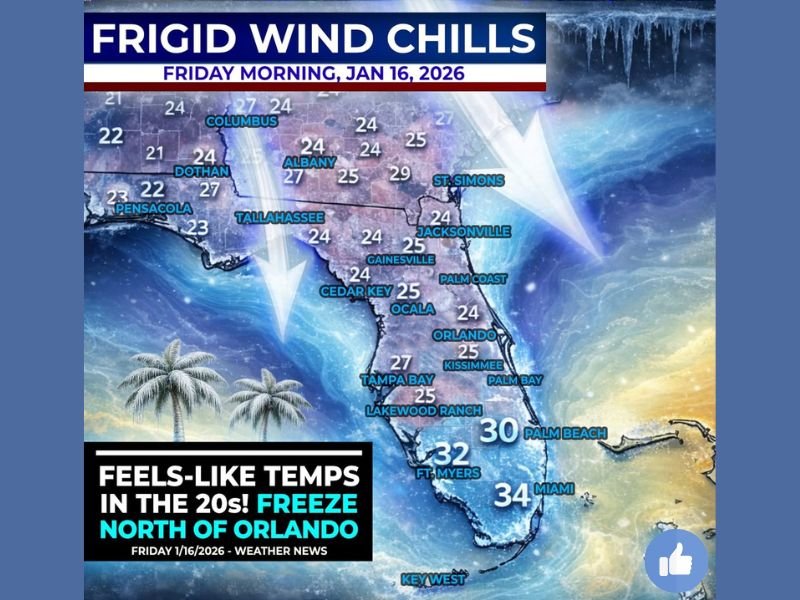
FLORIDA — A powerful surge of arctic air is set to sweep across Florida early Friday morning, bringing dangerously cold wind chills, freezing temperatures in central and northern areas, and conditions rarely experienced across the state. Forecasters warn that much of Florida will feel temperatures in the 20s at daybreak Friday due to strong winds and an unusually cold air mass. This cold outbreak is shaping up to be one of the most significant January cold snaps in decades for parts of the state.
Wind Chills in the 20s Across Much of Florida
According to forecast data, feels-like temperatures will plunge into the low to mid-20s across large portions of Florida, including areas not accustomed to prolonged cold. Gusty winds will intensify the chill, making conditions feel far colder than actual air temperatures. Meteorologists note that this setup creates hazardous exposure conditions, particularly for people working outdoors during early morning hours.
Freeze Likely North and West of Orlando
The coldest conditions are expected north and west of Orlando, roughly along and north of the Interstate 4 corridor. In these areas, a hard freeze is likely, with actual air temperatures dropping to or below freezing for several hours.
Cities including Gainesville, Ocala, Leesburg, and parts of the Nature Coast could see temperatures in the mid to upper 20s, cold enough to damage sensitive plants and expose plumbing to freezing risks.
Central Florida Faces Historic Cold
Forecasters say this could mark the coldest January 16th in central Florida in more than 40 years, and the coldest air to impact the region since the Christmas 2022 cold outbreak. Even areas south of the freeze line will feel unusually cold by Florida standards, with temperatures hovering just above freezing.
Miami and South Florida are expected to stay above freezing, but wind chills will still dip into the low 30s, an uncommon event for the region.
Impacts: Iguanas, Pipes, and Daily Life
Cold conditions are expected to be severe enough to cause falling iguanas, a phenomenon Floridians recognize during extreme cold snaps. Officials are urging residents in freeze-prone areas to protect pipes, bring pets indoors, and cover plants.
Travel impacts are not expected to be widespread, but early morning delays are possible due to the sudden temperature drop and strong winds.
More Cold May Follow
Meteorologists are also monitoring the potential for another cold front early next week, possibly bringing similar or even colder conditions by Monday into Tuesday. Confidence is growing that the overall pattern will remain colder than normal through mid-January.
Residents are encouraged to prepare for multiple mornings of unseasonably cold weather and avoid assuming this will be a one-day event. Have you experienced extreme cold in Florida before? Share how you’re preparing and join the conversation at SaludaStandard-Sentinel.com.