Pennsylvania Weather Outlook: Quiet Monday Follows Snow Squalls as Late-Week Storm Threat Emerges for Thursday and Friday
PENNSYLVANIA — Weather conditions across Pennsylvania are turning noticeably quieter Monday, following the snow squall activity that moved through the state over the weekend. While lingering cold air remains in place, forecasters say today’s conditions will be far less disruptive, even as attention begins shifting toward a potential late-week winter storm.
High temperatures Monday are expected to range from the upper 20s in northern and higher-elevation areas to the low 40s in the southeast, with partly to mostly cloudy skies statewide.
Monday Forecast: Cold but Mostly Calm Across the State
The immediate threat from Sunday’s snow squalls has ended, allowing for a more stable start to the week. However, a weak atmospheric disturbance may pass through parts of the state later this morning and into the afternoon.
This could bring isolated snow showers or flurries, particularly across northern Pennsylvania and higher elevations, where a light dusting cannot be ruled out. Any snowfall today is expected to be minor and short-lived, with no significant travel impacts anticipated.
Temperatures Remain Below Normal for Mid-January
Despite calmer conditions, cold air continues to dominate the region. Many communities will remain below seasonal averages, reinforcing that winter is firmly in control. Overnight lows tonight will dip back into the 20s statewide, setting the stage for continued cold conditions heading into midweek.
Late-Week Storm Potential Raises Concern
Forecasters are closely monitoring a developing weather pattern later this week, as a deep trough digs into the eastern United States. This setup could allow a low-pressure system to form, potentially impacting Pennsylvania Thursday into Friday.
At this stage, the magnitude and exact track of the storm remain uncertain. While snow is a possibility, meteorologists stress that it is far too early to determine amounts or impacts.
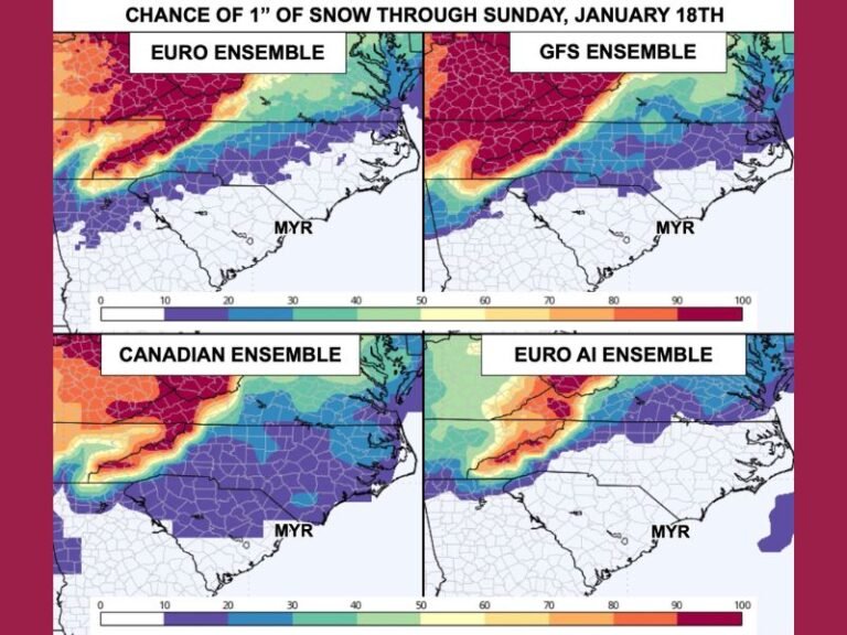
Why Snowfall Maps Should Be Ignored for Now
Weather officials urge residents to avoid reacting to early snowfall maps circulating online, emphasizing that model guidance is still evolving. Small shifts in storm track could result in very different outcomes, ranging from light snow to more impactful accumulations — or minimal effects at all. More detailed scenario breakdowns may be issued as confidence improves later in the week.
What Residents Should Do Now
For now, Pennsylvanians should enjoy the calmer conditions, remain aware of ongoing cold temperatures, and check back for updated forecasts as the late-week system comes into clearer focus. As always, SaludaStandard-Sentinel.com will continue monitoring developing winter threats and provide timely updates as new information becomes available. Stay safe, stay informed, and stay warm.