Strong Cold Front to Bring Rain and Isolated Thunderstorms Across Georgia Thursday Night
GEORGIA — Residents across Georgia should prepare for changing weather conditions late this week as a strong cold front moves through the region on Thursday evening, bringing a mix of rain, gusty winds, and isolated thunderstorms.
According to the North Georgia Weather Authority, rain will begin in the afternoon across northwestern parts of the state and spread eastward through the night. The system will mark the start of a significant pattern shift, ending the state’s recent mild streak and ushering in cooler, breezier conditions by Friday.
Cold Front Arrives Thursday Night With Rain and Thunder
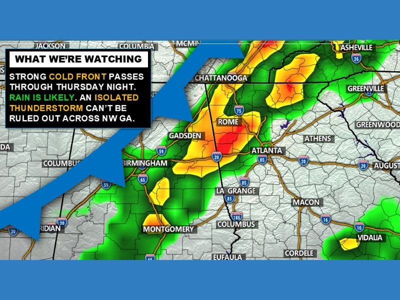
Meteorologists expect the leading edge of the front to reach west and northwest Georgia by Thursday afternoon, with the heaviest rainfall and potential thunderstorms arriving between 8 p.m. and midnight.
Forecast models show widespread rain across Rome, Cartersville, and Atlanta, with isolated thunderstorms possible mainly in the northwestern quadrant of the state. While severe weather is not anticipated, forecasters warn that brief rumbles of thunder, lightning, and localized downpours cannot be ruled out.
“A strong cold front will pass through Thursday night. Rain is likely, and an isolated thunderstorm can’t be ruled out across northwest Georgia,” forecasters noted in their late-Tuesday update.
Temperature Drop Follows the Front
Ahead of the front, high temperatures Thursday will climb to around 60°F, offering one last mild day before cooler air sweeps in overnight. Once the front moves through, readings will fall back into the upper 40s and lower 50s for highs on Friday, with morning lows dipping into the 30s in many areas.
Residents across Atlanta, Athens, and Macon can expect a noticeably cooler and breezier start to the weekend. Winds will shift northwest behind the front, adding to the chill factor through early Friday.
Rainfall Totals and Timing
- Timing: Rain develops Thursday afternoon, peaks overnight, and moves east by dawn Friday.
- Rainfall: Totals between 0.5 and 1 inch expected, higher in localized thunderstorm areas.
- Storm Risk: Limited to isolated thunderstorms; no widespread severe threat.
Rain is projected to clear the metro Atlanta and Athens areas by early Friday morning, allowing for partial sunshine to return by the afternoon.
Weekend Outlook: Cooler and Drier
Behind the system, drier air will take hold. The weekend forecast calls for sunny skies and highs in the 50s, with overnight lows dipping into the 30s statewide. It will feel much more seasonable heading into the final stretch of December.
Meteorologists say this front is part of a larger national pattern shift that will bring colder air across much of the eastern United States through early next week.
Residents planning to travel or attend outdoor events Thursday evening are urged to keep rain gear handy and monitor local forecasts for updates on storm timing.
For continuous updates on Georgia’s changing weather conditions, visit SaludaStandard-Sentinel.com.