Precipitation Outlook Shows Increased Rain Chances for California, Nevada, Arizona, Oregon, and Washington as Christmas Week Pattern Shifts Across the West
WEST COAST — After a dry start to December across much of the Southwest, new forecast guidance shows a shift in the storm pattern for Christmas week, bringing higher precipitation chances to California, Nevada, Arizona, Oregon, and Washington. The change follows a period of ridging that kept the Southwest unusually dry while directing storms into the Pacific Northwest.
Storm Track Has Favored the Pacific Northwest Early in December
Forecasters note that the Pacific Northwest has been the primary target for storms so far this month, continuing a pattern established after a record-wet November for parts of the West. Cities such as Seattle and Salem have remained under a steady flow of moisture, while the Southwest experienced prolonged dry conditions.
This trend is expected to hold through the next several days before a more significant pattern adjustment develops just before Christmas.
Ridge Breakdown Likely to Bring Increased Precipitation to the West
A strong signal is emerging for the breakdown of the ridging pattern during the week of December 19–25, opening the door for storms to slide farther south into the West Coast and interior Southwest.
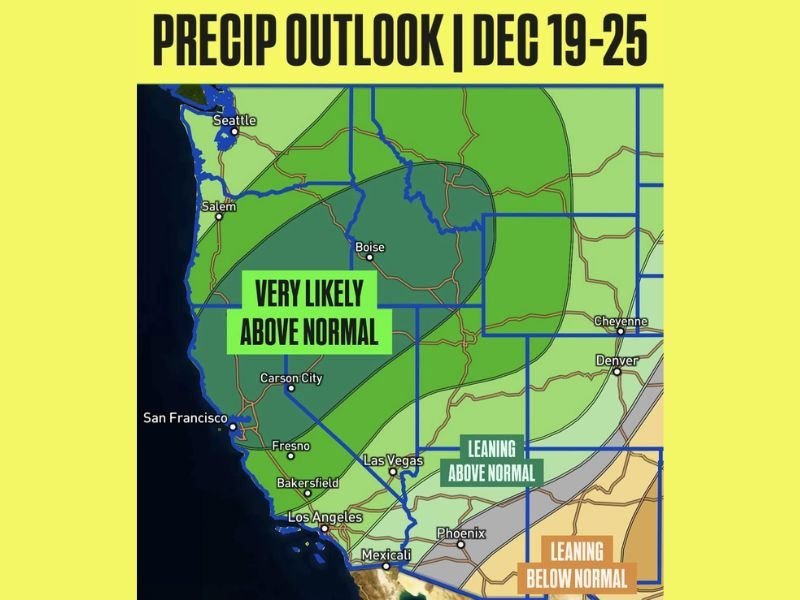
Model projections show the following outlook:
California and Nevada: Very likely above-normal precipitation, especially across the Sierra Nevada, Northern California, and western Nevada.
Arizona and Southern California: Leaning above normal for rainfall, with improved chances for moisture reaching the desert regions.
Oregon and Washington: Continued active pattern with opportunities for additional rounds of rain and mountain snow.
The shift is expected to help balance the month’s totals after what has been a noticeably dry start for California, Nevada, and Arizona.
Christmas Week Could Feature Widespread Rain and Mountain Snow
With the storm track redirecting toward the Southwest, Christmas week may bring lowland rain and significant mountain snowfall—particularly across higher elevations of California, Nevada, and Oregon. Snow levels will depend on the strength of each system, but the potential for multiple storm events appears increasingly likely.
Forecasters emphasize that the December 19–25 period could mark the most active stretch of weather for the West Coast so far this month, helping to boost early-season water supply for several states.
Residents preparing for changing conditions or noticing early signs of the incoming weather shift are encouraged to share updates with the community at SaludaStandard-Sentinel.com.