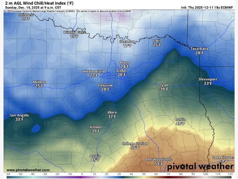
Very Cold Air to Sweep Into North Texas on Sunday With Wind Chills Dropping Into the Teens Across Areas North of Dallas–Fort Worth
TEXAS — A surge of very cold air is expected to move into North Texas on Sunday, bringing wind chills that may fall into the mid-teens across areas north of the Dallas–Fort Worth metroplex. Forecast models show a sharp drop in temperatures during the morning hours, creating one of the coldest days so far this season for many communities in the region.
Wind Chills in the Teens for Areas North of DFW
Model data highlights significant cold spreading into counties north of DFW, with wind chills projected as low as 15 to 17 degrees in cities such as Sherman, Wichita Falls, and Paris.
Across the Metroplex itself, Sunday morning wind chills are forecast to drop to 24°F in Plano and 28°F in Dallas, marking a noticeable and sudden arrival of Arctic air.
Weatherford, Cleburne, and Abilene will also feel the brunt of the cold, with wind chills ranging from 22°F to 28°F during the morning period.
Central and Eastern Texas Remain Cold but Less Severe
While the most intense chills remain focused north of the metro area, much of Central and Eastern Texas will also experience colder-than-normal conditions.
Forecast values show 37°F in Waco, 39°F in Killeen, and 33°F in Shreveport, indicating a broad cooling trend across the region.
Austin and College Station will remain on the warmer edge of the cold surge, with wind chills of 45°F and 56°F, respectively, while deep East Texas locations such as Lufkin will hover near 48°F.
Cold Surge Marks One of the Strongest Arrivals This Month
Forecasters note that this incoming blast represents one of the most significant cold surges for North Texas so far in December. The combination of falling temperatures and gusty north winds will create dangerous wind chills, particularly during the early morning hours.
Although no winter precipitation is associated with this event, residents should prepare for rapidly changing conditions, especially in rural and elevated areas more prone to colder air drainage.
Cold Expected to Ease as the Week Progresses
The very cold air will moderate gradually as the week moves forward. Temperatures are expected to rebound during the afternoon hours on Monday and continue improving through midweek, returning the region to more typical December conditions.
North Texas residents preparing for the Sunday cold blast or monitoring local temperature trends can share updates with the community at SaludaStandard-Sentinel.com.