Texas and Oklahoma Brace for Strong Cold Front Bringing 45 MPH Wind Gusts and Freezing Temperatures
DALLAS, TEXAS — A powerful Arctic cold front has pushed through much of North and Central Texas and parts of Oklahoma, dropping temperatures sharply overnight and ushering in gusty winds that are giving residents a harsh taste of winter.
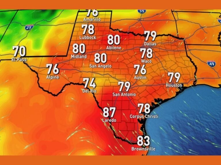
According to forecasters, the front is moving through the Dallas-Fort Worth metroplex, bringing temperatures that will continue to fall throughout the night and wind gusts reaching 35 to 45 miles per hour.
Sharp Drop in Temperatures Across Texas
Meteorologists report that most of North Texas will wake up Sunday morning to a hard freeze, with wind chills plunging into the low 20s and some rural areas potentially dipping even lower.
Cities including Dallas, Fort Worth, Abilene, Wichita Falls, and Amarillo are experiencing a rapid shift from mild fall conditions to winter cold. The National Weather Service warns of dangerously cold wind chills early Sunday morning, urging residents to limit outdoor exposure, protect pets, and cover sensitive plants.
“It’s a strong, fast-moving front that’s bringing a sudden reality check for Texans,” one forecaster explained. “This is our first true taste of winter — and it’s not done yet.”
Cold Air Expands Southward
The cold front is expected to continue moving south through Austin, San Antonio, and Houston, where temperatures will fall sharply late Saturday into Sunday.
- Austin and San Antonio may see lows in the upper 20s to mid-30s by sunrise.
- Houston will drop into the 40s, marking its first significant cool-down of the season.
Meanwhile, Oklahoma City and Tulsa are forecast to remain below freezing through much of Sunday, with highs barely reaching the upper 30s.
Strong Winds Add to the Chill
Wind gusts of 35 to 45 mph have been reported across the metroplex, making the air feel even colder. The combination of strong northerly winds and dropping temperatures has created hazardous wind chills across much of North and Central Texas.
Drivers are also urged to use caution, especially on highways and overpasses where crosswinds could make travel difficult for high-profile vehicles.
Another Cold Front on the Way
Forecasters say this isn’t the last cold blast for the week. Another strong front is expected to arrive by Thursday, reinforcing the Arctic chill and keeping temperatures below average for at least the next seven days.
This secondary system could bring additional gusty winds and freezing conditions across North Texas and Oklahoma, signaling a continued winter trend as December begins.
Preparing for the Cold
Residents are encouraged to take standard cold-weather precautions:
- Bring pets indoors and cover outdoor pipes.
- Protect sensitive vegetation from frost.
- Check on elderly neighbors or those without reliable heating.
Meteorologists note that while no snow or ice is expected from this particular front, the combination of wind and cold will make it feel bitterly frigid — especially during early mornings and evenings.
As the region braces for back-to-back cold surges, Texas and Oklahoma are officially stepping into winter mode.
Stay informed with regional updates and weather alerts at SaludaStandard-Sentinel.com.