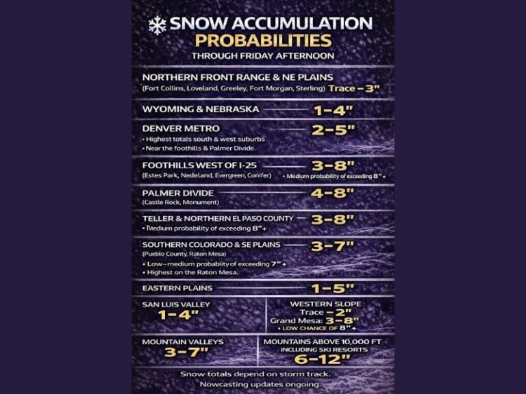
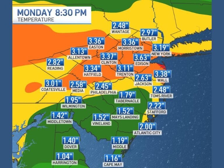
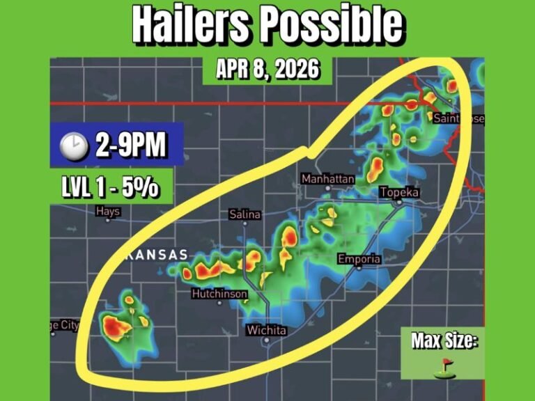
Severe Weather Threat Targets Texas Saturday: Strong Cold Front to Bring Damaging Winds, Hail, and Possible Tornadoes
TEXAS — Forecasters are warning of severe weather across Central, East, and Southeast Texas today as a strong cold front sweeps through the state, triggering storms capable of producing damaging winds, hail, and even isolated tornadoes late Saturday evening.
Meteorologists say instability will rise rapidly through the afternoon and evening hours, especially after 2 p.m., setting the stage for a line of fast-moving storms that could impact millions of Texans from Dallas to Houston.
Cold Front Triggers Rapid Storm Development
According to forecast models, scattered showers began forming early Saturday, with the main line of storms expected to develop along the cold front by mid-afternoon. The front will move swiftly through North Texas, reaching the Dallas–Fort Worth area around 3 p.m., bringing a burst of gusty winds up to 45 mph, small hail, and heavy downpours.
As the evening progresses, storm activity is expected to intensify further south and east, impacting Austin, College Station, Beaumont, and Houston between 6 p.m. and midnight.
“This will be a quick-moving line, with individual storms lasting only 15 to 20 minutes,” forecasters noted. “However, some could pack a punch with strong gusts, hail, and even a brief tornado spin-up overnight.”
Damaging Winds and Nighttime Tornado Risk
The Storm Prediction Center (SPC) has highlighted much of central and southeastern Texas under a Level 2 (Slight Risk) for severe weather. Increasing wind shear later tonight — particularly after 9 p.m. — will enhance the potential for rotating storms capable of producing isolated nighttime tornadoes.
Wind gusts of up to 65 mph are possible in the most intense cells, especially across the Houston metro area and surrounding counties. In addition, hail up to the size of quarters and rapid temperature drops are expected as the front passes.
Areas of Concern
The greatest threat zone includes:
- Houston and surrounding suburbs
- College Station and The Woodlands
- Austin to San Antonio corridor
- Beaumont and East Texas communities near Lufkin and Tyler
Residents in North Texas, including Dallas and Fort Worth, will see a lower chance of severe weather, though isolated strong storms could still develop briefly before colder, drier air settles in.
Wind Gusts and Rapid Temperature Drop
Behind the cold front, temperatures are expected to fall sharply, with wind chills dropping into the 30s across northern and central Texas overnight. Gusts of 35–45 mph will persist well after the storms move through, making outdoor conditions uncomfortable and potentially hazardous for travelers.
Safety and Preparedness
Emergency officials urge residents to stay alert through Saturday night and have multiple ways to receive weather alerts, particularly since some of the most dangerous storms could occur after dark.
Safety tips include:
- Keep your phone charged and volume on for emergency alerts.
- Avoid travel during severe storms, especially in high-wind zones.
- Secure outdoor furniture and loose objects before evening.
- Know your nearest shelter location in case of a tornado warning.
“This setup brings a real risk of overnight tornadoes — which are especially dangerous since they strike when most people are asleep,” meteorologists warned. “Stay weather aware until the front clears your area.”
Outlook
After the front passes, Sunday will bring clear skies and much cooler temperatures, with highs only in the 50s and 60s. However, another storm system may form mid-next week as Gulf moisture returns under a strengthening La Niña pattern.
Residents across Texas should remain cautious and continue monitoring local forecasts for updated alerts.
Stay tuned for real-time severe weather updates and safety alerts on SaludaStandard-Sentinel.com.