Major Winter Storm Slams Midwest With Up to 18 Inches of Snow Expected From Iowa to Chicago Through Saturday
MIDWEST — A powerful winter storm is sweeping across the Midwest overnight, delivering heavy snowfall, hazardous travel conditions, and blizzard-like winds across several states from Iowa and Illinois to Wisconsin and Michigan.
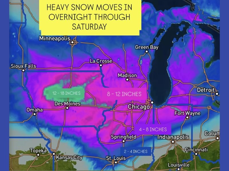
Forecasters say the storm, which began late Friday, will intensify through Saturday, producing widespread snow totals between 8 and 12 inches, with some isolated areas seeing as much as 18 inches of accumulation.
Heavy Snowfall Targets Major Cities
According to meteorological models, the heaviest snow bands will move eastward across Iowa, northern Illinois, and southern Wisconsin overnight, bringing near-whiteout conditions in spots.
- Des Moines, Iowa: 12–18 inches expected
- Chicago, Illinois: 8–12 inches possible
- Springfield, Illinois: 4–8 inches likely
- St. Louis, Missouri: 2–4 inches projected
- Madison, Wisconsin: Heavy snow exceeding 10 inches possible
Forecasters are urging residents to stay off the roads where possible as travel becomes increasingly treacherous. The National Weather Service has issued multiple Winter Storm Warnings across the region, warning of rapidly deteriorating conditions overnight.
“Snowfall rates could exceed one inch per hour at times, especially in central Iowa and northern Illinois,” the NWS said. “Gusty winds may also reduce visibility, making travel extremely dangerous or impossible in some areas.”
Travel Disruptions and Power Concerns
The storm is already causing flight cancellations and delays across major Midwest airports, including Chicago O’Hare and Midway, where crews are working around the clock to keep runways clear.
Road crews across Iowa, Illinois, and Wisconsin are preparing for extended snow removal operations as snowbands continue through Saturday. Motorists are urged to avoid travel unless absolutely necessary.
Officials also warned of scattered power outages in rural and suburban areas as heavy, wet snow accumulates on power lines and trees.
Cold Air Locks In Behind the System
Behind the main snow band, temperatures will plummet, with wind chills dropping below zero in some parts of the upper Midwest by early Sunday.
“This system will mark the coldest and snowiest weekend of the season so far,” meteorologists said. “Arctic air will settle in through early next week, keeping highs below freezing across much of the region.”
Residents Urged to Prepare
Authorities are advising residents to stock up on essentials, including food, water, and heating fuel, before the storm’s peak intensity. For those already in the storm’s path, emergency officials recommend staying indoors, keeping cell phones charged, and checking on elderly neighbors.
The Illinois Department of Transportation cautioned that conditions could worsen overnight, particularly along Interstate 80, Interstate 55, and Interstate 90, where visibility may drop to near zero at times.
Widespread Impact Across the Midwest
By Saturday evening, snow will continue spreading northeast toward Michigan and northern Indiana, where additional accumulations are expected before tapering off by Sunday morning.
Even after the snow ends, blowing and drifting will remain a concern as winds increase behind the system. Forecasters say roads could remain slick well into the weekend.
As one meteorologist put it:
“If you’re waking up to a blanket of snow tomorrow, plan to stay home. This storm is bringing the kind of snow that shuts down travel and keeps snowplows running nonstop.”
Stay tuned for continuous coverage and official updates on SaludaStandard-Sentinel.com, where our team will track the Midwest storm’s progress and report on local impacts as the situation develops.