Powerful Midwest Winter Storm to Drop Up to 15 Inches of Snow Across Iowa, Northern Illinois, and Southern Wisconsin
CHICAGO, ILLINOIS — A major winter storm is expected to slam the Midwest this weekend, bringing heavy snow, gusty winds, and hazardous travel conditions across multiple states. Meteorologists warn that the system could drop 6 to 12 inches of snow across a large swath of the region, with some areas seeing totals as high as 15 inches.
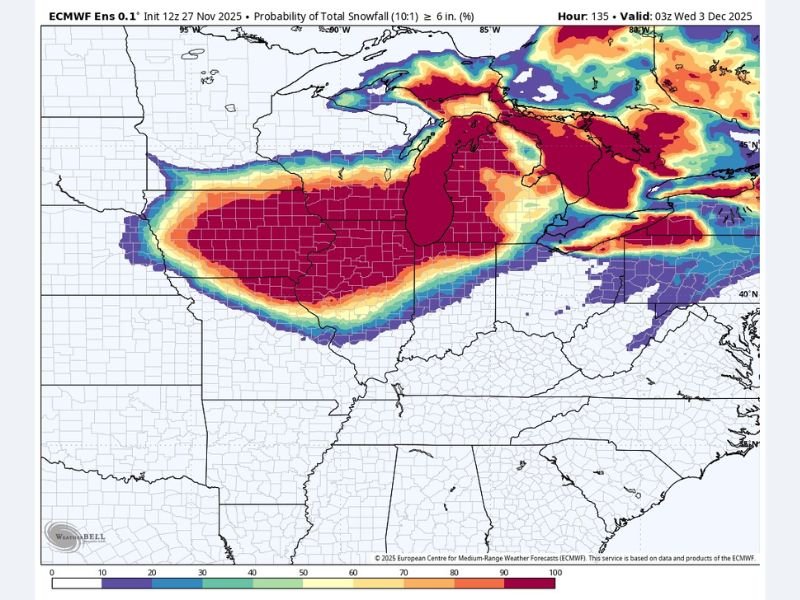
The latest data from the European Centre for Medium-Range Weather Forecasts (ECMWF) shows the storm intensifying late Friday night before sweeping across Iowa, northern Illinois, and southern Wisconsin on Saturday, with snow spreading into Michigan and northern Indiana by Sunday.
Heavy Snow Band to Stretch from Iowa to Michigan
Forecasters expect a broad corridor of heavy snow extending from eastern Nebraska and Iowa through northern Illinois and into southern Wisconsin and Michigan’s Lower Peninsula.
Key snowfall projections include:
- Des Moines, Iowa: 10–14 inches possible
- Dubuque, Iowa: 8–12 inches
- Rockford, Illinois: 8–10 inches
- Chicago, Illinois: 6–9 inches
- Madison, Wisconsin: 8–12 inches
- Milwaukee, Wisconsin: 6–8 inches
- Grand Rapids, Michigan: 6–10 inches
Localized pockets in northeastern Iowa and southern Wisconsin could approach 15 inches, according to ECMWF model probabilities.
“This is a high-impact system for one of the most densely traveled corridors in the Midwest,” said meteorologists monitoring the storm. “Anyone driving along I-80, I-90, or I-94 this weekend should prepare for dangerous conditions and rapidly deteriorating visibility.”
Blowing Snow and Whiteout Conditions Expected
Strong northwest winds behind the storm will create blowing and drifting snow, further reducing visibility across open areas. Gusts could reach 30–40 mph at times, making it difficult for plows to keep up with rapidly falling snow.
Forecasters warn that whiteout conditions could make travel nearly impossible during the height of the storm, especially across rural Iowa and northern Illinois.
The National Weather Service (NWS) has already issued Winter Storm Watches for much of the affected region, with warnings likely to follow as the storm approaches.
“This storm will have the potential to bring widespread impacts across the Midwest,” the NWS said. “If travel is necessary, plan ahead and carry a winter survival kit.”
Major Travel Disruptions Expected
The timing of the storm could not be worse for post-Thanksgiving travelers returning home.
Airports in Chicago, Des Moines, and Milwaukee are expected to experience significant flight delays and cancellations, while road conditions across major interstates will likely become treacherous.
Officials advise travelers to:
- Check airline and highway updates frequently before leaving.
- Keep emergency supplies such as blankets, food, and flashlights in vehicles.
- Avoid driving at night or during periods of heavy snow.
Local road crews are preparing for round-the-clock plowing operations, but forecasters warn that snowfall rates could exceed one inch per hour, quickly overwhelming cleanup efforts.
Cold Blast to Follow the Snow
After the storm passes, a sharp drop in temperatures is expected across the Midwest, with lows plunging into the teens and single digits by early next week.
Wind chills may dip below zero across Iowa, Wisconsin, and northern Illinois, keeping the new snowpack firmly in place.
Residents are urged to protect exposed pipes, bundle up, and check on vulnerable neighbors as the cold front sweeps in.
Outlook
While snow is expected to taper off by Sunday morning, lake-effect snow could continue over eastern Wisconsin and western Michigan, adding several more inches in localized bands.
Meteorologists will continue monitoring the storm’s track, which could still shift slightly north or south before landfall — changing where the heaviest snow falls.
“This is shaping up to be a textbook Midwest snowstorm,” one forecaster said. “The key message is simple: travel early, stay alert, and be ready for rapidly changing conditions.”
Stay tuned to SaludaStandard-Sentinel.com for continuous updates, advisories, and live weather alerts throughout the weekend as the winter storm unfolds across the Midwest.