Severe Weather Threat Moves Across the South: Texas, Oklahoma, Arkansas, and Mississippi Under Risk of Strong Storms and Tornadoes
OKLAHOMA CITY, Okla. — The Storm Prediction Center (SPC) has issued a new Day 1 and Day 2 Severe Weather Outlook, warning residents across Texas, Oklahoma, Arkansas, Louisiana, Mississippi, and Alabama to prepare for strong storms, damaging winds, hail, and possible tornadoes as a slow-moving cold front makes its way through the South.
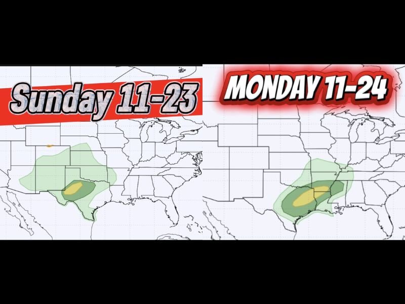
According to the outlook, the areas highlighted in dark green and yellow face the greatest risk, particularly on Sunday, November 23, through Monday, November 24.
Storm System to Sweep Eastward Through Monday
Meteorologists say the front will begin in central and north Texas on Sunday, moving through western Oklahoma before shifting east into Louisiana, southern Arkansas, Mississippi, and western Alabama by Monday morning.
The cold front could deliver severe thunderstorm clusters, hail up to quarter size, and tornado activity, particularly in the yellow-risk zones.
Residents are urged to stay alert and avoid being outdoors unnecessarily once evening storms begin rolling in.
Overnight Threats Raise Safety Concerns
The National Weather Service cautioned that some of the most dangerous storms could develop overnight, catching people off guard.
Residents are being urged to activate mobile alerts and keep weather radios on during the night.
“If you’re in the dark green or yellow zone, tonight is not the night to sleep without your phone charged,” one meteorologist warned humorously. “If that siren goes off at 2 A.M., you don’t want to be running outside like a confused rotisserie chicken in the front yard.”
While the comment drew laughs online, officials say the message is serious — tornado warnings after midnight are among the deadliest because many people are asleep and unaware.
Meteorologists Advise Preparedness and Calm
Local weather experts recommend keeping a go-bag ready with essentials, including flashlights, power banks, and water.
Homeowners should also secure outdoor furniture, clear drainage paths, and move vehicles away from trees in case of high winds.
By early Tuesday, the system is expected to weaken as it moves east toward Georgia and the Carolinas, but lingering showers and gusty winds may continue in the region.
Weather Safety Tips
- Monitor alerts from the National Weather Service.
- Stay indoors during thunderstorm warnings and avoid windows.
- Have multiple ways to receive alerts, especially overnight.
- If a tornado warning is issued, move to a small, windowless room or basement immediately.
- Avoid driving in heavy rain or near flooded areas.
Officials stress that even if your area is not in the high-risk zone, strong wind gusts and flash flooding are possible along the storm’s path.
Stay tuned for more updates on regional impacts as the system tracks eastward.
Stay aware, stay safe — and as one forecaster put it, stay dressed.