European and GFS Models Show 5–6 Inches of Rain Possible for Alabama and the South Through Early December
ALABAMA — New long-range model data shows the South may be heading into a significantly wetter pattern as both the European model (ECMWF) and the American GFS model signal high-end rainfall totals across Alabama and surrounding Southern states through early December.
Meteorologists say the developing pattern could bring multiple rounds of rain, including some very heavy batches, in the days following Thanksgiving weekend.
Models Indicate 5–6 Inches of Rain Possible Over Two Weeks
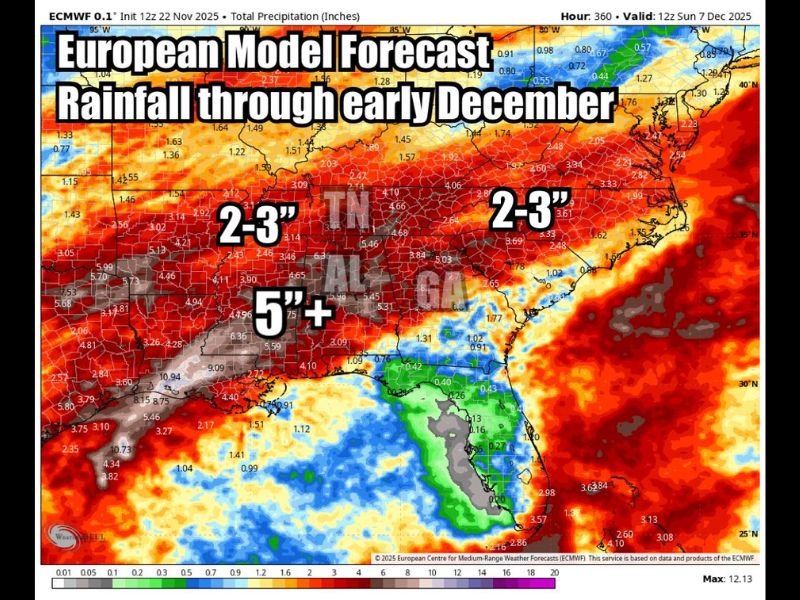
Forecast data shared Saturday highlights totals of 5 to 6 inches across central and northern Alabama, with surrounding states such as Mississippi, Tennessee, Georgia, Arkansas, and Louisiana also projected to see widespread 2–3 inch totals.
According to the ECMWF model viewed through WeatherBell Analytics, this amount of rainfall is not unusual for Alabama in late fall but would mark a notable shift to a wetter pattern after recent dry stretches.
Meteorologists say these totals represent “high-end rain” for early December but not necessarily extreme.
Rain Expected Every Few Days as Active Pattern Develops
Forecasters note that the region is entering a multi-day storm cycle that should deliver rain “every few days,” with some systems producing locally heavy downpours.
Model data suggests the first significant wave of rain arrives Tuesday, with additional rounds expected in the back half of Thanksgiving weekend and into early next week.
Experts say this is the type of rainfall distribution that can recharge soil moisture, benefit reservoirs, and reduce fire risk in areas that have been unusually dry.
Early December is a Secondary Severe Weather Peak
While meteorologists agree this setup will be active, early model guidance does not highlight a clear or organized severe weather threat at this time.
However, forecasters caution that early December is historically a secondary peak of severe weather season in the Deep South, meaning that any strong storm cycle warrants close monitoring.
Experts say that with multiple storm systems moving through, the probability of a severe-weather episode somewhere in the region is not zero — even if no obvious signal stands out yet.
Southern States Expected to Benefit From Widespread Rain
According to the model projection, the following regions will see meaningful rainfall:
- Central and Northern Alabama — 5″+
- Mississippi, Tennessee, Georgia — 2–3 inches
- Arkansas and Louisiana — 2–3 inches
- South Alabama and Florida Panhandle — lower totals due to coastal dry influence
The heaviest band runs from eastern Texas through Louisiana, across Mississippi, and into Alabama, aligning with a classic cool-season storm track.
Residents Encouraged to Monitor Forecast Updates
Meteorologists say that while heavy rainfall is expected, the timing, intensity, and storm structure of each wave may shift. Residents are encouraged to stay alert for updates as the Thanksgiving holiday period transitions into an increasingly active weather pattern.
If you’re in Alabama or anywhere in the South and want to share what the upcoming rain means for your community, join the conversation at SaludaStandard-Sentinel.com.