Winter Weather Threat Expected Across Texas, Oklahoma, Louisiana, Missouri, Illinois, Indiana, Tennessee From December 28 to January 6
UNITED STATES — A major pattern shift is forming across the country, and long-range guidance is signaling a significant increase in winter weather threats stretching from Texas, Oklahoma, Arkansas, Louisiana, Missouri, Illinois, Indiana, Kentucky, and Tennessee from December 28 through January 6.
Following an unusually warm Christmas period, a strong surge of Arctic air and a more active storm track could bring snow, sleet, ice, and multiple rounds of precipitation to millions of residents across the central and eastern United States. While specific snowfall totals and precise impact zones remain uncertain, meteorologists agree the overall pattern is becoming more amplified — and more wintry.
Why the Pattern Is Changing
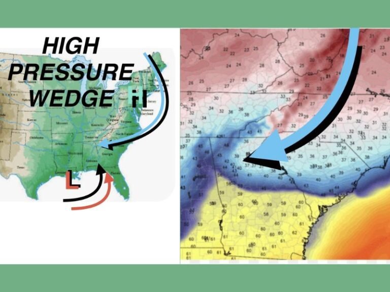
A key driver of this upcoming shift is the North Atlantic Oscillation (NAO), which turned negative and is forecast to remain negative into mid-January. A negative NAO slows the atmospheric pattern enough to allow colder Arctic air to dig farther south, setting the stage for winter weather across the central and southern U.S.
At the same time, meteorologists are tracking a large reservoir of Arctic cold now building across Alaska and western Canada. If the atmospheric pattern locks in, this air mass could flow directly into the Southern Plains, Mid-South, and Ohio Valley, dramatically lowering temperatures.
Much of this season has felt very La Niña–like, with cold air focused mainly over the Midwest and only brushing the South. But the latest data shows that dynamic may change sharply as we move toward New Year’s.
What the Affected States Could See
As colder air presses into the region, the subtropical jet stream also appears ready to strengthen — a combination that could produce:
- Multiple precipitation events
- Higher potential for snow, sleet, or freezing rain
- More active storm systems tracking across the central U.S.
- Much-needed rainfall for areas that have been unusually dry
- Travel impacts during the holiday period
The highlighted threat zone stretches from New Mexico and Texas eastward through Oklahoma, Arkansas, Louisiana, Missouri, Illinois, Indiana, Kentucky, and Tennessee, with some of the highest potential in the Mid-South and Ohio Valley corridor.
Important Reminder: This Is a Pattern Outlook, Not a Storm Forecast
Meteorologists caution that this is NOT a specific forecast.
There are:
- No exact precipitation amounts
- No confirmed track for individual storms
- No city-level snowfall projections yet
This is strictly a pattern-based signal showing where conditions may become more active and wintry as we enter late December and the first week of January.
Still, the consistency of the long-range indicators makes this a winter pattern worth watching closely.
What to Expect Going Forward
If the pattern evolves as projected:
- Colder air will spill into the Southern Plains and Midwest
- Storm systems may form along the new temperature boundary
- Wintry precipitation chances will increase in the listed states
- Holiday and post-holiday travel may face disruptions
Short-range models will begin to clarify specific snow zones and timing as the event window approaches. Stay with Saluda Standard-Sentinel for the latest updates as the winter threat window nears. For more developing weather reports, visit SaludaStandard-Sentinel.com.