Winter Weather Models Show Growing Snowfall Potential Across Tennessee, Alabama, Georgia, and the Carolinas in Early December
ATLANTA, GEORGIA — The South may be gearing up for its first taste of winter weather this season, as new model projections show a growing chance for measurable snowfall across parts of Tennessee, Alabama, Georgia, and the Carolinas between December 2 and 9.
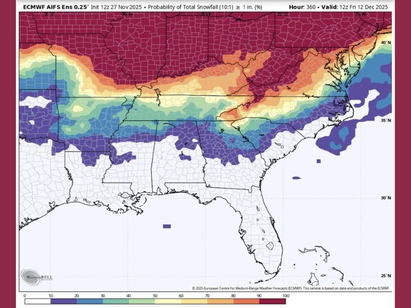
According to the European Centre for Medium-Range Weather Forecasts (ECMWF) ensemble output, areas across the central and southern Appalachian corridor are showing probabilities ranging from 30% to over 70% for receiving at least one inch of snow. While the confidence in exact totals remains moderate, forecasters say the setup is becoming increasingly favorable for a Southern winter event early next month.
Snow Probabilities Rising Across the Southeast
The latest model run paints a wide band of potential snowfall from eastern Oklahoma and northern Mississippi across Tennessee, northern Alabama, north Georgia, and into the western Carolinas.
- 30–50% probability zone: Northern Alabama, north Georgia, and upstate South Carolina.
- 50–70% probability zone: Central Tennessee and western North Carolina.
- 70–100% probability zone: Kentucky, Virginia, and higher elevations of the Appalachians.
Forecasters emphasize that these percentages represent snow probability, not accumulation, meaning there’s growing confidence that wintry precipitation will occur somewhere within this zone — even if totals vary widely.
“This is one of the stronger early-season signals we’ve seen for Southern snow so far,” one meteorologist explained. “The models are showing a consistent corridor of cold air and available moisture around the December 2–9 timeframe.”
Cold Air Setting the Stage
The potential snow event coincides with a powerful Arctic air mass expected to settle over much of the U.S. during the same period. Forecasts show temperatures dipping 15–25 degrees below normal across several Southeastern states, setting the stage for snow or sleet if sufficient moisture arrives.
Cities such as Nashville, Birmingham, and Greenville could see their first wintry mix of the season, while Asheville and Knoxville are positioned for a more defined snowfall risk. Even areas farther south — including Atlanta and northern Alabama — are not entirely out of play if temperatures continue to trend downward.
A Classic Southern Setup
This pattern reflects a classic “Southern snow belt” scenario, where an active subtropical jet stream carries Gulf moisture northeast into an entrenched Arctic air mass. These setups often lead to surprise snowfalls in regions unaccustomed to them — but also produce uncertainty due to their sensitivity to timing and temperature changes.
Meteorologists caution that while excitement is growing, this remains a model projection, not an official forecast.
“It’s too early to talk accumulation, but it’s not too early to prepare,” said weather analyst Jason Huffman. “If the models continue to hold this pattern, parts of the Deep South could see a light snow event between the 2nd and 9th.”
Model Consistency and Early Caution
The ECMWF AIFS ensemble shows multiple runs confirming the snow corridor, lending increased confidence to the trend. However, the GFS model remains less aggressive, favoring colder but drier conditions. This difference means residents should monitor updates closely over the coming week, as model alignment typically improves five to seven days before the event.
For now, the southern snow probabilities break down roughly as follows:
- 10–30% chance: Central Alabama and north Georgia (minor flurries or trace possible)
- 40–60% chance: Northern Alabama, Tennessee Valley, and western Carolinas
- 70–90% chance: Central and eastern Tennessee, southern Kentucky, Blue Ridge Mountains
What Residents Should Know
If current trends hold, the early December storm could bring:
- First measurable snowfall for the Tennessee Valley and foothill regions
- Icy travel conditions on bridges and secondary roads
- Power interruptions if sleet or wet snow develops in higher elevations
- School and business delays across northern Alabama and Georgia
Officials are advising residents to begin winterizing homes, checking vehicles, and preparing for possible travel disruptions.
Outlook
The ECMWF forecast continues to suggest an active early-December weather pattern across the eastern half of the country. A second cold surge is likely around December 9–12, which could reinforce the winter trend and bring another round of potential snow or ice to the South.
Forecasters will monitor how quickly Arctic air penetrates the region and whether sufficient Gulf moisture overlaps with the cold front — two key factors that could determine if the Southeast sees flurries or a full-on snowfall event.
Stay tuned to SaludaStandard-Sentinel.com for continuing updates and local weather advisories as early December’s Southern snow potential evolves.