Western North Carolina, Upstate South Carolina, and North Georgia Face Escalating Ice Storm Threat as Models Push Crippling Ice Farther South
CAROLINAS & NORTH GEORGIA — New hurricane-hunter-fed model data shows a rapidly increasing ice storm threat across Western North Carolina and the South Carolina Upstate, with dangerous ice totals now extending farther south into North Georgia, including the Atlanta area, and east toward Columbia, South Carolina. Each new model run is adding confidence that this will be a high-impact, long-duration ice event, not a brief winter weather disturbance.
Ice Totals Increasing and Expanding Southward
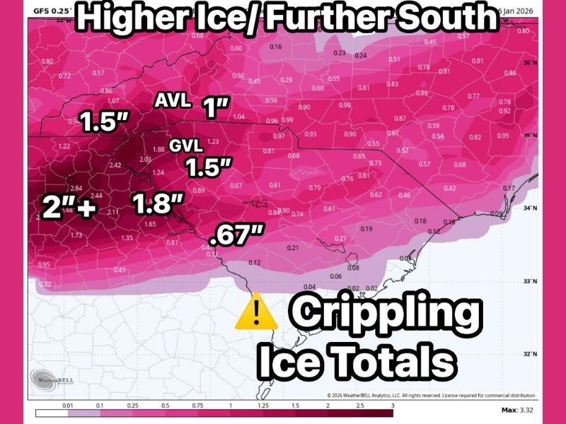
The latest model output indicates widespread ice accumulations exceeding one inch across parts of Western North Carolina, with 1.5 inches or more possible in the higher terrain and foothills. Some pockets near the Blue Ridge are now showing potential totals approaching or exceeding 2 inches of ice, which would be crippling for trees, power infrastructure, and travel.
Farther south, Upstate South Carolina, including areas near Greenville, and extending toward Columbia, is now firmly inside the expanding ice zone. Model projections in these areas range from 0.6 to over 1 inch of ice, which is more than enough to cause widespread power outages and dangerous road conditions.
Atlanta and I-20 Corridor Now at Risk
One of the most concerning developments is the southward expansion of the ice threat into North Georgia, including the Atlanta metro area. The data shows significant icing potential along and north of the I-20 corridor, with freezing rain likely to persist long enough to accumulate on trees, bridges, and power lines.
This southward shift dramatically increases the population impact of the storm and raises concerns for major travel disruptions, especially on elevated roadways and untreated surfaces.
Timing: Impacts Begin Saturday, Linger Into Sunday
Current guidance suggests ice impacts may begin by midday Saturday and continue well into Sunday, making this a long-duration event rather than a short burst of freezing rain. Prolonged icing significantly increases the risk of:
- Tree damage
- Downed power lines
- Extended power outages
- Hazardous travel conditions lasting beyond the end of precipitation
Why This Setup Is Especially Dangerous
This event is shaping up as a classic high-impact ice storm, with cold air firmly locked in place at the surface while moisture continues to override it. That setup favors efficient freezing rain accumulation, especially in foothill and Piedmont regions.
Even ice amounts under one inch can cause major problems. Ice totals near or above one inch, as currently indicated in parts of the region, are considered crippling by winter weather standards.
Confidence Increasing With Each Model Run
Forecasters stress that each successive model update is reinforcing the same solution, increasing confidence that significant icing will occur somewhere across Western North Carolina, Upstate South Carolina, and North Georgia. While exact placement of the highest totals may still shift slightly, the overall threat is becoming clearer and more widespread.
Bottom Line: Prepare for a High-Impact Ice Event
This is not a minor winter weather setup. The latest data supports a dangerous ice storm capable of widespread disruption, particularly along and north of I-20, through the Western Carolinas, and into North Georgia.
Residents in these areas should prepare now for potential power outages, extremely hazardous travel, and prolonged impacts. Additional updates are expected as new data continues to roll in. Stay with SaludaStandard-Sentinel.com for continued, location-verified coverage as this evolving ice storm threat becomes clearer.