Weekend Snow Potential Develops Across North Georgia and Western Carolinas as Models Show Increasing but Uncertain Winter Signal
GEORGIA — Forecasters are tracking a developing chance for snow this weekend across North Georgia and parts of the western Carolinas, with early signals indicating that accumulating snow is possible but far from guaranteed. Meteorologists emphasize that several atmospheric features must align perfectly for snow to reach this far south, keeping the forecast uncertain with three days still to go.
Models Suggest Snow Is Possible, but Not Guaranteed
The update notes that the “rumors are true,” with a decent chance for weekend snow now appearing on multiple forecast models. However, it remains only a chance, not a confirmed event. Forecasters warn that small changes in storm timing, placement or strength can significantly shift the outcome, particularly in southern regions where winter weather requires precise alignment.
Current model possibilities range from accumulating snow to a dry outcome with snow staying farther south, underscoring the need for continued monitoring.
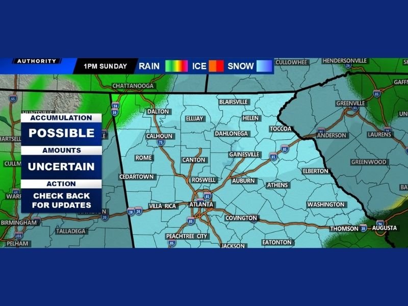
Accumulation Possible but Amounts Still Uncertain
The weather graphic identifies three key messages for the weekend:
- Accumulation: Possible
- Amounts: Uncertain
- Action: Check back for updates
The map highlights widespread light-blue shading across areas including Atlanta, Rome, Dalton, Canton, Gainesville, Athens, Washington, Elberton, Covington, Peachtree City and communities extending into the western Carolinas.
This shading represents the current snow-potential zone for 1 p.m. Sunday, with rain and ice possible outside the primary region.
Why the Forecast Is Still Highly Variable
Forecasters explain that to see snow reach North Georgia, several atmospheric ingredients must come together perfectly. These include the availability of moisture, proper timing of colder air and the strength of key upper-level disturbances.
Any shift in these variables could:
- Increase the chance of accumulating snow
- Reduce it to flurries
- Push the snow zone southward entirely
Because these details remain fluid, confidence is rising—but not yet solid.
More Clarity Expected Later Today
The update promises a more refined forecast later today, as new data becomes available. With three days remaining before the event, model signals are expected to sharpen considerably.
Residents across North Georgia and the western Carolinas are encouraged to stay alert for updated information as this evolving winter setup becomes clearer. Readers can share snowfall expectations or local conditions at SaludaStandard-Sentinel.com.