Washington State Braces for Powerful Pineapple Express Atmospheric River Bringing Days of Heavy Rain Toward Seattle and Cascades
WASHINGTON STATE — Meteorologists are warning that a powerful “Pineapple Express” atmospheric river could bring several days of steady rain to Western Washington next week, raising concerns about rising rivers, mountain snowmelt, and localized flooding across parts of the region.
The incoming storm system is expected to target areas around Seattle, the Cascade Mountains, and nearby river basins, delivering warm Pacific moisture that may persist for much of the week.
Forecasters say the event follows an already remarkable stretch of weather that recently brought Seattle’s windiest day of the season with gusts near 52 mph, its snowiest day with about 3 inches of snowfall, and the second-rainiest day of the storm season — all within roughly 48 hours.
Atmospheric River Aiming Moisture Toward Washington
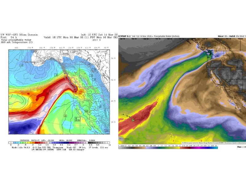
Weather models show a large plume of tropical moisture stretching across the Pacific Ocean and pointing toward the Pacific Northwest. This type of system, often called a Pineapple Express, forms when moisture from near Hawaii is carried northeast toward the U.S. West Coast.
Forecast models indicate the plume will first move toward British Columbia late Sunday into Monday, bringing light to moderate rain on the southern edge of the system.
By Tuesday through Friday — and possibly into Saturday — the moisture stream is expected to shift south and focus directly over Western Washington, bringing several days of persistent rainfall.
Meteorologists say Wednesday currently appears to be the wettest and windiest day, as a low-pressure disturbance moves along the atmospheric river.
Rainfall Totals Could Reach Several Inches
While this atmospheric river is not expected to produce extreme rainfall rates, the long duration of the storm could allow rainfall totals to build steadily throughout the week.
Current projections suggest:
- 2 to 4 inches of rain in lowland areas
- 5 to 8 inches of precipitation in the mountains, particularly in the North and Central Cascades
Snow levels are expected to rise significantly — potentially reaching around 9,000 feet — meaning much of the existing mountain snowpack may begin melting or washing away as rain replaces snow.
This could place additional pressure on rivers and streams that drain from the mountains.
Flood Risk Being Closely Monitored
River forecast models suggest several well-known flood-prone rivers in Western Washington — including the Snoqualmie, Snohomish, and Skykomish Rivers — could rise toward “Action Stage,” which typically represents about 80 to 100 percent of flood-stage levels. At this point, forecasters say only the Skokomish River, which frequently floods during heavy rain events, has a notable risk of exceeding flood stage.
However, officials say conditions will continue to be monitored closely, as long-duration rainfall can gradually push rivers higher over time. Unlike previous winter flooding events, snowpack in the mountains may absorb some rainfall initially, which could help limit rapid runoff.
Pacific Northwest Storm Arrives as U.S. Weather Turns Extreme
The atmospheric river event in Washington is just one part of a dramatic national weather pattern unfolding across the United States.
Meteorologists say the same large-scale pattern could simultaneously bring:
- A historic heat wave across California and the Desert Southwest
- A potentially historic blizzard across the Upper Midwest and Great Lakes
- A dangerous severe weather setup across parts of the Southeast and Mid-Atlantic
In Arizona, some forecasts suggest Phoenix could exceed 100°F for five consecutive days in March, something that would challenge long-standing temperature records.
Meanwhile, the atmospheric river on the western edge of the pattern will continue funneling moisture into the Pacific Northwest.
What Residents Can Expect This Week
Forecasters say Sunday may begin relatively dry across Western Washington, but rain is expected to develop later in the day as Pacific moisture begins moving inland. Once the atmospheric river settles over the region, residents should expect periods of rain nearly every day through the week, along with occasional breezy conditions.
Mountain resorts that recently saw significant snowfall may see rain instead of snow for much of the coming week, particularly at lower elevations. Officials advise residents living in river valleys and flood-prone areas to monitor forecasts and prepare for possible rising water levels as the week progresses.
For now, forecasters say the system appears more likely to bring persistent rain rather than a high-impact flooding event, but the long duration means conditions could change if rainfall totals climb higher than expected. Residents across the Pacific Northwest are encouraged to stay alert for forecast updates as the atmospheric river approaches.