United States Weather Pattern Poised for Repeated Arctic Cold Intrusions as Mid-December Amplification Builds
UNITED STATES — Meteorologists are warning that the overall U.S. weather pattern heading into mid-December is showing no signs of letting up — and may, in fact, intensify. Forecast models suggest that the jet stream will become increasingly wavy, allowing for repeated Arctic air intrusions across the central and eastern United States, while the West Coast remains under a strong ridge of high pressure.
According to new EURO model projections, the pattern will amplify between December 10 and December 15, creating sharp temperature contrasts from coast to coast. This setup — featuring a western ridge and an eastern trough — will reinforce a corridor for cold, dry air to repeatedly surge southward into the Midwest, Great Lakes, and interior South.
What the Data Shows
The latest 500mb height anomaly maps indicate that deep troughing will dominate the eastern half of the country by December 12, signaling multiple rounds of below-average temperatures. Areas across the Upper Midwest, Great Lakes, Ohio Valley, and Northeast could experience several consecutive cold fronts, each delivering bursts of Arctic air.
Meanwhile, the West Coast will continue basking in unseasonably mild and dry weather, courtesy of a persistent ridge pattern centered over California and the Pacific Northwest.
This atmospheric alignment — ridge in the West, trough in the East — is known to produce “see-saw temperature patterns” where the Plains and Southeast cool dramatically while the Southwest stays warm and dry.
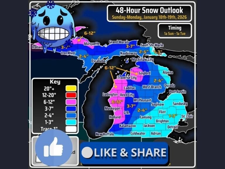
Meteorologists also note that the orientation of this pattern could set up an active Alberta Clipper storm track, bringing frequent snow events across the Great Lakes and into the interior Northeast.
Cold Air Set to Spill Repeatedly into the East
The amplified jet stream is acting as a conveyor belt for polar air masses, which will continue spilling southward from Canada. These repeated cold air intrusions are expected to:
- Drop temperatures 10–25°F below normal in many central and eastern U.S. cities.
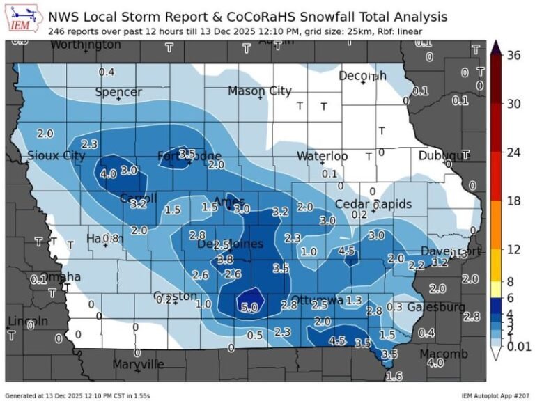
- Increase the likelihood of light-to-moderate snowfall across northern regions.
- Trigger wind chill values in the single digits for parts of the Midwest and Great Plains.
Forecasters are watching for potential impacts as early as December 8–9, with the strongest cold surge projected around December 12–13. If the pattern persists, colder-than-average conditions could extend through the third week of December.
Western Warmth, Eastern Freeze
While the eastern half of the country braces for a deep freeze, residents in California, Arizona, Nevada, and Oregon can expect continued warmth and dry air as the upper-level ridge locks into place. The setup is likely to suppress storm development in the West, raising concerns about prolonged dryness and low mountain snowpack heading into late December.
In contrast, the Southeast and Appalachians could experience increased volatility, with sharply fluctuating temperatures and occasional moisture intrusions from Gulf systems. This could create potential freezing rain or sleet episodes if Arctic air remains entrenched near the surface.
What to Expect Moving Forward
Meteorologists describe the mid-December forecast as one of “persistence with punch” — meaning the overall pattern will remain consistent but could produce more extreme swings.
“The setup is locked in,” one atmospheric analyst said. “The cold air is ready to reload and strike multiple times as the jet stream dips repeatedly into the central and eastern U.S. The real question is how strong each surge will be.”
For now, long-range guidance suggests a classic December divide:
- West: Warm, dry, and stable under high pressure.
- Central and East: Cold, stormy, and active with multiple Arctic fronts.
Residents across the Midwest, Great Lakes, and Northeast should prepare for frequent temperature drops, snow showers, and gusty winds through the second half of the month.
For continuing updates on national and regional weather shifts, follow SaludaStandard-Sentinel.com for detailed forecasts and impact reports.