Two Tornado Warnings Issued Near Poplarville Mississippi as Separate Storm Circulations Track North and South of Pearl River County
MISSISSIPPI — A dangerous and fast-evolving weather situation developed near Poplarville as two separate tornado warnings were issued across parts of Pearl River County, with rotating storms tracking both north and south of the area.
The warnings highlight two distinct storm circulations moving through the region, placing multiple communities in the potential path of tornadic activity within a short time frame.
Two Separate Rotating Storms Detected Near Poplarville
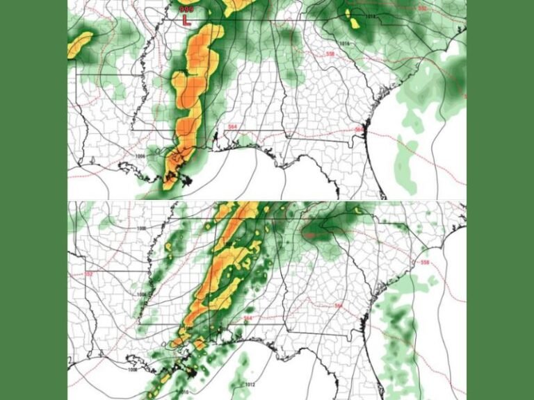
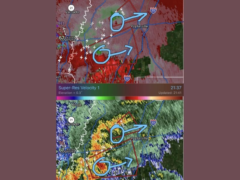
Radar velocity and reflectivity imagery revealed two areas of rotation embedded within a larger storm system. One circulation appeared to be tracking north of Poplarville, while another was moving just south of the city. This unusual setup created a dual-threat scenario, where areas on both sides of Poplarville were at risk simultaneously.
Storms Moving in Different Paths Increase Risk Area
The northern storm was projected to pass above Poplarville, while the southern circulation tracked below the city. This effectively expanded the zone of concern across much of central Pearl River County. Communities along and near Interstate 59 were particularly vulnerable as both storms progressed through the region.
Strong Rotation and Lightning Indicate Active Storms
Radar data showed strong velocity signatures and heavy precipitation cores within both storms, along with frequent lightning activity. These are key indicators of potentially dangerous thunderstorm development. Such conditions can support brief tornado formation, even if the storms are not long-lived or widespread.
Residents Urged to Take Immediate Shelter
With two tornado warnings in effect simultaneously, officials emphasized the importance of taking immediate action. Residents in the warned areas were urged to seek shelter in interior rooms on the lowest floor of sturdy buildings.
Situations involving multiple storm circulations can change rapidly, increasing the need for constant monitoring and quick response.
Rapidly Changing Conditions Expected Through Warning Period
As both storms continue to move, their intensity and track could shift, potentially impacting additional areas beyond the immediate warning zones.
Even after the warnings expire, lingering thunderstorms may still bring heavy rain and gusty winds across the region.
Ongoing Monitoring Required as Storms Move Through
Forecasters are closely tracking both circulations as they move across Pearl River County. Updates may be issued if either storm strengthens or new areas of concern develop.
Residents are encouraged to remain weather aware and keep alert systems active until conditions fully clear. If severe weather is impacting your area, share your updates with us at SaludaStandard-Sentinel.com to help keep others informed during this rapidly evolving situation.