Tornado Watches Cover Mississippi, Tennessee, Kentucky and Indiana as Overnight Storm Line Targets Nashville, Louisville and Indianapolis
MISSISSIPPI, TENNESSEE, KENTUCKY AND INDIANA — A powerful nighttime severe weather outbreak is unfolding across the central United States as a long line of intense thunderstorms pushes north, triggering multiple tornado watches from the Gulf Coast into the Ohio Valley.
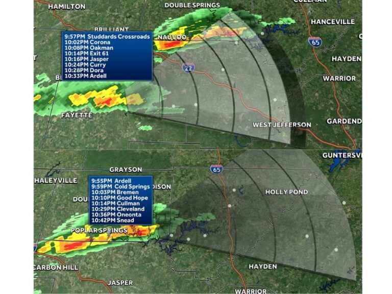
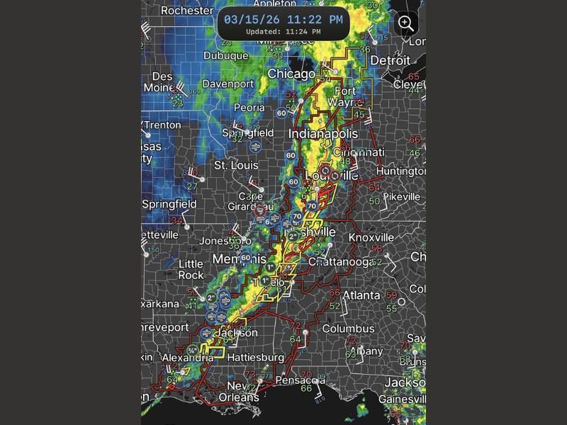
Weather radar late Sunday night shows a large and organized line of storms stretching from southern Mississippi through Tennessee and into Indiana, with major cities including Jackson, Nashville, Louisville and Indianapolis in the potential path of severe weather.
Meteorologists warn that storms moving through the region overnight could produce damaging winds, isolated tornadoes, and large hail as the system tracks northeast.
Tornado Watches Issued Across Several States
Red watch boxes displayed on radar indicate active tornado watches across portions of Mississippi, Tennessee, Kentucky and Indiana, where atmospheric conditions are favorable for tornado development.
A tornado watch means conditions are supportive of tornadoes and severe thunderstorms, though tornado warnings would be issued if rotation is detected in storms. Communities across the watch area are being urged to remain alert overnight as the storms move through.
Powerful Storm Line Moving North Through the Region
The main line of storms appears to be forming a strong squall line, a type of organized thunderstorm system capable of producing widespread damaging wind gusts.
Radar imagery shows heavy thunderstorms extending from Louisiana and Mississippi north through Tennessee into Indiana, creating a corridor of intense rainfall and strong winds. Cities including Jackson, Memphis, Nashville, Louisville and Indianapolis are positioned near or ahead of the advancing line of storms.
Damaging Winds and Tornadoes Possible Overnight
Meteorologists say the greatest threat overnight will likely be damaging straight-line winds, which can reach severe levels as the storm line accelerates.
However, storms embedded within the line may also rotate and produce isolated tornadoes, particularly where wind shear is strongest.
In addition to tornadoes and wind damage, some storms could produce hail and intense lightning as they move rapidly across the region.
Overnight Severe Weather Poses Added Risk
Severe storms occurring during nighttime hours can be especially dangerous because people may be asleep when warnings are issued.
Emergency officials emphasize the importance of having multiple ways to receive weather alerts, such as smartphone warnings, NOAA weather radios, or local broadcast alerts that can wake residents if conditions worsen. Residents within tornado watch areas are advised to remain prepared to move quickly to a safe shelter if a tornado warning is issued.
Storm System Expected to Continue Moving Northeast
The storm line is expected to continue advancing northeast overnight and into early Monday morning, gradually shifting toward the Ohio Valley and parts of the Mid-Atlantic.
As the system moves forward, additional communities across the eastern United States could experience severe thunderstorms and damaging winds.
Forecasters say conditions will continue evolving overnight as meteorologists track the movement and intensity of the storm system. If severe weather impacts your community, share local updates and conditions with the newsroom at SaludaStandard-Sentinel.com so readers across the region can stay informed as the overnight storm system continues to unfold.