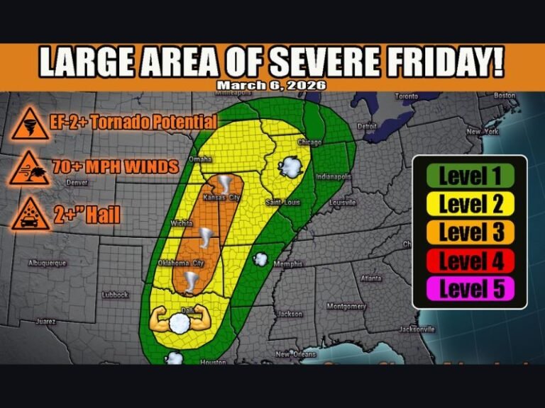
Texas, Oklahoma, Kansas, Missouri and Illinois Enter 10-Day Storm Pattern With Repeated Severe Weather Risk From April 14 Through April 18
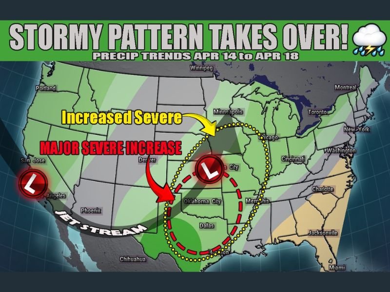
UNITED STATES — A major shift in the weather pattern is expected to unfold over the next 10 days, bringing repeated rounds of storms and increasing severe weather potential from Texas and Oklahoma through Kansas, Missouri, and into Illinois.
Forecast signals point to a “reloading” setup, where storm systems repeatedly develop and move across the same general corridor.
Storm Pattern Begins to Lock In Across Southern Plains
The developing pattern centers around a persistent trough and southwest flow, which will act as a trigger for repeated storm development.
This setup is expected to focus activity across Texas and Oklahoma initially, where moisture, instability, and wind energy combine to create favorable conditions for thunderstorms. Cities such as Dallas and Oklahoma City are positioned near the core of this evolving storm zone.
Severe Weather Risk Expands Toward Kansas and Missouri
As the pattern progresses, storm activity is expected to shift northeast into Kansas and Missouri, where conditions may become increasingly favorable for stronger storms.
This region sits within a highlighted corridor for enhanced severe potential, suggesting multiple days where storms could intensify. The repeated nature of the system raises the likelihood of several rounds of thunderstorms rather than a single outbreak.
Midwest Including Illinois Could See Increased Activity
Farther north and east, areas including Illinois and parts of the Midwest are expected to experience an uptick in storm activity as the system tracks through the region.
Cities like Chicago could see periods of unsettled weather as storm systems push northeast. While not every day will bring severe conditions, the overall pattern supports multiple opportunities for storms.
Multiple “Chase Days” Embedded in Pattern
One of the most notable aspects of this setup is the number of potential severe weather days embedded within it. Rather than a one-day event, this pattern suggests several opportunities for storms to develop, intensify, and impact different areas along the corridor. This increases the chance for repeated impacts, including strong winds, hail, and heavy rainfall.
Central Corridor From Texas to Midwest Remains Focus Area
The highest concentration of storm activity is expected along a central corridor stretching from Texas through Oklahoma and Kansas into Missouri and Illinois.
This region aligns with the strongest atmospheric dynamics, making it the most likely zone for severe weather development during this period. Areas outside this zone may still see rain and storms, but the most active conditions are expected within this corridor.
Pattern Signals an Active Stretch Ahead
This setup is consistent with a classic spring severe weather pattern, where energy continues to reload and produce storms over several days.
While specific storm details will evolve, the broader signal is clear: an active and potentially impactful stretch of weather lies ahead.
Residents across the Southern Plains and Midwest should stay alert as conditions change daily. Are you in the path of this upcoming storm pattern? Share your expectations and preparations with us at SaludaStandard-Sentinel.com.