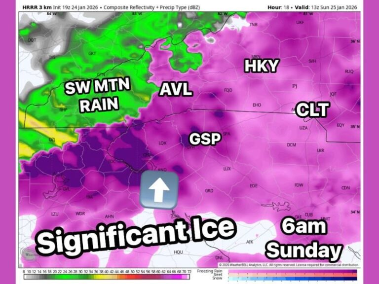
Texas, Oklahoma, Colorado, and Illinois Could Turn Milder Feb. 6–10 While New York, Virginia, and the Carolinas Stay Stuck in Winter
UNITED STATES — A developing temperature trend for February 6–10 suggests a growing divide across the country, with Texas, Oklahoma, Colorado, Nebraska, and parts of Illinois poised for a milder pattern, while New York, Virginia, and the Carolinas remain entrenched in a colder winter setup that has dominated much of the season.
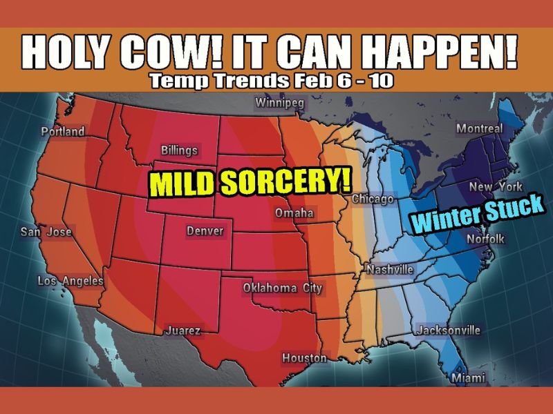
A Milder Pattern Is Emerging Across the Plains and Midwest
Forecast temperature shading shows widespread warm anomalies building across the central United States, particularly from Texas north through Oklahoma, Kansas, Colorado, and Nebraska, with the milder air pressing into parts of the Midwest. Cities such as Denver, Omaha, and Oklahoma City sit well within the warmer zone, signaling a noticeable break from repeated cold intrusions.
For these states, the pattern favors several days of above-normal temperatures, allowing afternoons to feel significantly milder compared to recent weeks. While not a full transition to spring, the setup represents one of the stronger warm signals seen so far this winter for the central U.S.
Illinois and Nearby Midwest States Could Briefly Join the Warm Side
The outlook shows the warmer air pushing eastward far enough to reach Illinois and surrounding Midwest states, placing areas near Chicago close to the transition zone. Even a modest eastward shift in the ridge would be enough to deliver a temporary warm-up, offering relief after prolonged cold spells.
However, the proximity to the colder eastern trough means temperature swings could be sharp, with warmth arriving quickly and departing just as fast if the boundary shifts.
New York, Virginia, and the Carolinas Remain Locked in Winter
In contrast, the eastern half of the country remains shaded in cooler tones, reflecting persistent troughing that has dominated much of the winter. New York, Virginia, North Carolina, and South Carolina all fall on the cold side of the pattern, with little indication that sustained warmth will reach these areas during the Feb. 6–10 window.
Even when brief moderation occurs, the broader setup favors colder-than-normal conditions continuing across the East, reinforcing the idea that winter is far from finished for these states.
The Southeast Stays on the Cold Side of the Divide
Across the Southeast, including the Carolinas and parts of Georgia, the forecast suggests continued influence from the eastern trough. While Florida may sit closer to the boundary, cooler air remains close enough to limit any long-lasting warm-up, especially across North and Central Florida.
This reinforces the sharp regional contrast, where central states enjoy milder air while the East struggles to shake winter’s grip.
Why This Split Pattern Matters Heading Into Mid-February
This type of west-to-east temperature split often leads to rapid swings, strong frontal boundaries, and increased forecast volatility, especially along the dividing line between warm and cold air. For residents in the Plains and Midwest, the upcoming period may finally feel like a break. For the East, it signals continued patience as winter patterns remain stubborn.
As February progresses, how long this split lasts will determine whether the East eventually warms—or remains stuck while the middle of the country pulls ahead.
Are you seeing signs of warming where you live, or does winter still feel firmly in control? Share your local conditions and stay updated with ongoing coverage at SaludaStandard-Sentinel.com.