Texas, Oklahoma, Arkansas, Tennessee, and Southern Appalachia Face Potentially Historic Winter Storm With Feet of Snow and Widespread Ice Threat
UNITED STATES — A rapidly intensifying winter storm is drawing growing concern across Texas, Oklahoma, Arkansas, Tennessee, and the Southern Appalachian region, as the latest GFS model data signals the potential for extreme snowfall totals, significant ice accumulation, and widespread power disruptions. Meteorologists say new data assimilation, including Hurricane Hunter dropsonde readings, has dramatically sharpened the forecast — and not in a reassuring way.
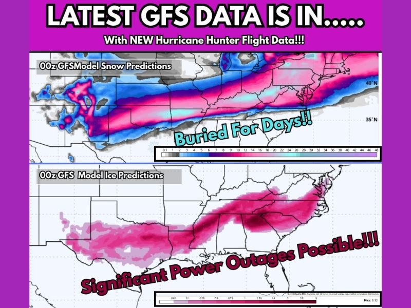
Why the Latest GFS Data Is Raising Alarms
The newest GFS run shows a long-duration, high-impact winter storm corridor stretching from the Southern Plains into the Appalachians, with multiple hazards unfolding simultaneously. Forecast guidance indicates snowfall rates and ice accretion high enough to cripple travel and infrastructure, especially in regions not accustomed to prolonged winter extremes.
Meteorologists caution that while exact placement will still shift, the overall magnitude of the storm signal has increased, not weakened.
Snowfall Potential: Feet Possible in the Southern Plains
According to current projections, eastern Oklahoma and western Arkansas are positioned beneath a zone where snow totals could approach or even exceed two feet in localized areas. This would be an exceptional snowfall event for the region, especially given the likelihood of strong winds, which could lead to near-blizzard conditions and drifting snow.
If these totals materialize, roads may become impassable for days, and emergency services could face significant delays.
Ice Storm Setup Across the South and Appalachians
Farther south and east, the threat shifts from snow to freezing rain and sleet, particularly across parts of Texas, Arkansas, Tennessee, Kentucky, and Southern Appalachia. The GFS continues to indicate ice accumulations exceeding one inch in some areas — a level meteorologists describe as crippling.
Ice of this magnitude can:
- Snap trees and power poles
- Bring down power lines
- Cause prolonged outages lasting days or longer
- Make travel virtually impossible
Even 0.25 inches of ice can cause major damage; projections well above that threshold elevate this storm into a high-risk category.
Power Outages and Infrastructure Risks
One of the most serious concerns tied to this setup is the potential for widespread power outages. Heavy ice clinging to lines and tree limbs significantly increases the risk of grid failures, particularly in rural and wooded areas.
While power generation facilities may fare better than during past historic freezes, local distribution networks remain highly vulnerable to ice loading and falling debris.
Why This Storm Could Last for Days
Unlike fast-moving winter systems, this storm is expected to stall and evolve over several days, allowing snow and ice to accumulate continuously rather than in short bursts. This increases the likelihood of:
- Extended road closures
- Delayed recovery efforts
- Compounding impacts from cold, wind, and precipitation
Meteorologists emphasize that this is not a one-round event — multiple waves of winter weather are possible.
What Residents Should Do Now
Officials urge residents across the impacted states to begin preparations immediately, focusing on:
- Non-perishable food and water
- Backup heat sources
- Charging devices and power banks
- Securing pets and livestock
- Avoiding unnecessary travel during peak impacts
Preparation now could make a significant difference if power or mobility is lost for an extended period.
A High-Confidence, High-Impact Forecast
While exact snowfall and ice lines will continue to adjust, meteorologists stress that this is not a low-probability scenario. The signal for a major, disruptive winter storm is strong across multiple models and data sources.
Have you experienced major snow or ice storms in your area before? Share how you’re preparing and stay informed with continued updates at SaludaStandard-Sentinel.com.