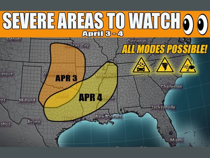
Texas, Oklahoma, Arkansas, Louisiana, Mississippi and Tennessee Face Severe Storm Threat With Tornado and Large Hail Risk April 3 and 4
UNITED STATES — A developing storm system is expected to bring a renewed severe weather threat across parts of the Southern Plains and Mid-South from April 3 into April 4, with the potential for tornadoes, large hail, and damaging winds.
Forecast guidance shows a more organized surface system forming by Friday, setting the stage for concentrated severe weather before shifting eastward into the weekend.
Developing Storm System Could Trigger Severe Weather Outbreak
Weather models indicate that a more organized low-pressure system will begin to take shape by April 3, helping to create favorable conditions for severe thunderstorms.
This setup is expected to pull instability and moisture northward, creating an environment supportive of strong to severe storms. The combination of wind shear and atmospheric energy could allow storms to intensify quickly. This type of pattern is often associated with multiple severe hazards occurring at once, including tornadoes and large hail.
April 3 Targets Texas and Oklahoma With Initial Severe Risk
The first round of severe weather is expected to develop across Texas and Oklahoma on April 3, where the core of the storm system begins organizing.
These areas could see the strongest storm development early in the event, with the potential for rotating storms capable of producing tornadoes. Large hail and damaging wind gusts will also be possible as storms intensify. Cities near Dallas and Oklahoma City may be within the zone where conditions are most favorable for severe weather during this phase.
April 4 Expands Threat Into Arkansas, Louisiana, Mississippi and Tennessee
By April 4, the system is expected to shift eastward, expanding the severe weather threat into Arkansas, Louisiana, Mississippi, and Tennessee.
As the cold front pushes forward, storms may become more widespread, increasing the coverage of severe weather across the region. This phase could bring multiple storm modes, meaning a mix of hazards including tornadoes, hail, and strong winds could all occur within the same system.
All Severe Weather Modes Possible Including Tornadoes and Large Hail
Forecast signals suggest that “all modes” of severe weather may be possible with this setup. This includes tornado development, very large hail, and damaging straight-line winds.
The presence of strong wind fields combined with unstable air increases the likelihood that some storms could become intense. While the exact placement of the highest risk areas is still being refined, the overall setup supports a potentially active severe weather period.
Forecast Uncertainty Remains in Timing and Placement
Although confidence is increasing in a severe weather event, there are still some uncertainties regarding the exact timing and location of the strongest storms.
Small shifts in the system’s track could change which areas see the highest impacts, especially between April 3 and April 4. Officials have not yet outlined specific high-risk zones, but current projections highlight the Southern Plains and Mid-South as key areas to monitor.
Residents across these regions should stay alert as forecasts are updated and be prepared for possible severe weather warnings. Stay informed and share your local conditions or concerns by visiting SaludaStandard-Sentinel.com.