Texas, Oklahoma, Arkansas, Louisiana, Mississippi, Alabama and Tennessee Face Multi-Day Severe Storm Threat as Active April Pattern Intensifies
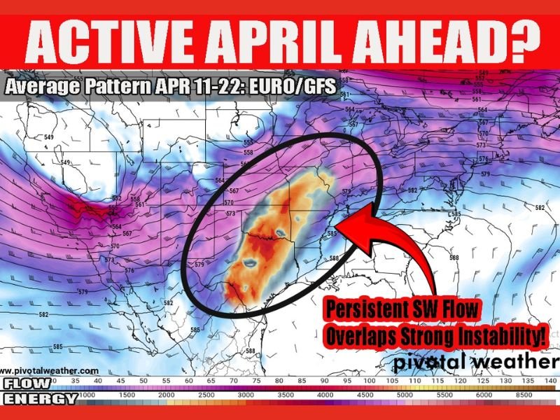
UNITED STATES — A potentially dangerous and persistent weather pattern is developing across Texas, Oklahoma, Arkansas, Louisiana, Mississippi, Alabama, and Tennessee, with signals pointing toward multiple rounds of severe storms over the next 7 to 10 days starting this weekend.
Forecast guidance indicates a strong and continuous southwest flow combined with a reloading storm pattern, raising concerns that this may not be a single event but an extended period of active severe weather across the region.
Strong Jet Stream and Instability Aligning Over Southern States
Current atmospheric analysis shows a powerful overlap between the mid-level jet stream and increasing instability across the Southern Plains and into the Mississippi Valley. This alignment is often a key trigger for widespread severe weather outbreaks.
The presence of strong upper-level winds alongside high energy levels in the atmosphere creates favorable conditions for storm organization. When these ingredients combine, storms can become more intense and long-lasting, increasing the likelihood of damaging winds, large hail, and isolated tornadoes.
This setup is particularly concerning because it stretches across multiple states, meaning impacts could be widespread rather than isolated.
Reloading Pattern Could Bring Repeated Storm Rounds
One of the most significant concerns with this setup is its persistence. Instead of a one-time storm system, this pattern appears to continuously reload, allowing new rounds of storms to develop over several consecutive days.
As warm, moisture-rich air continues to flow northward from the Gulf, it fuels instability across Texas through Tennessee. At the same time, disturbances moving through the jet stream will act as triggers for storm development.
This repeated cycle increases the risk of cumulative impacts, including flash flooding and prolonged severe weather threats in the same areas.
Weekend Storm Risk Marks the Beginning of Active Period
The first round of severe weather is expected to begin this weekend, with early indications already highlighting parts of the Southern Plains and Lower Mississippi Valley.
However, this initial activity may only represent the start of a much more active stretch. As the pattern holds steady, additional waves of storms could follow shortly after, extending the threat well into the following week.
While exact storm locations and intensity levels remain uncertain beyond the weekend, the overall signal for continued activity remains strong.
Why This April Setup Is Raising Concerns
April is typically one of the most active months for severe weather in the United States, but this particular setup stands out due to its consistency and strength.
A sustained southwest flow transports warm, humid air into the region while cooler air aloft increases atmospheric instability. This combination creates an ideal environment for storm development.
Additionally, strong wind shear associated with the jet stream enhances the potential for rotating storms, which can lead to tornado formation. The combination of these factors is why this pattern is being closely monitored.
Uncertainty Remains but Awareness Is Critical
Although forecast models are strongly aligned in showing an active period ahead, there is still uncertainty regarding the exact placement and timing of the most intense storms.
Weather patterns can shift, and small changes can significantly impact which areas experience the highest risk. However, the consistency of the signal suggests that residents across the affected states should remain prepared.
The key concern is not just a single storm event but multiple rounds of severe weather that could increase risks over time. Residents are encouraged to stay updated with local forecasts and be ready to act if severe weather warnings are issued in the coming days.
As this developing situation unfolds, have you started preparing for the upcoming severe weather season? Share your thoughts and local updates with us at SaludaStandard-Sentinel.com.