Texas, Oklahoma, and Arkansas Face Potential Extreme Weekend Snowfall as Early Forecasts Show Double-Digit Accumulations
SOUTHERN PLAINS — A very early but increasingly concerning snowfall outlook suggests parts of Texas, Oklahoma, and Arkansas could see heavy to potentially extreme snow totals this weekend, as a strengthening winter system aligns with long-signaled forecast trends.
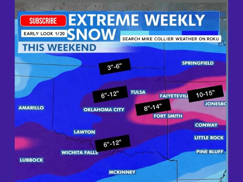
Early Snowfall Maps Highlight a High-Impact Winter Setup
Meteorologists caution that early snowfall projections will fluctuate, but the overall signal has been consistent for more than a week, pointing toward a significant winter storm capable of producing widespread snow across the southern Plains and Ozarks.
The latest outlook shows a well-defined band of heavier snowfall developing where cold Arctic air overlaps with deep moisture, a classic setup for efficient snow production.
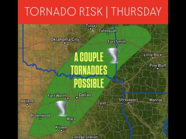
Oklahoma and North Texas in the Core Snow Band
Forecast guidance places central and southern Oklahoma firmly within the core of the storm, with early estimates suggesting 6 to 12 inches of snow possible around Oklahoma City, Lawton, and Wichita Falls. Portions of north Texas, especially near the Red River, could also see several inches of accumulation, enough to significantly disrupt travel.
Snowfall of this magnitude would be highly disruptive for the region, where snow removal resources are limited and even moderate totals can shut down road networks.
Arkansas Could See Some of the Heaviest Totals
Parts of northwest and north-central Arkansas, including areas near Fayetteville and Fort Smith, are currently highlighted for 8 to 14 inches of snow, with some localized projections even higher. These totals would be historic for parts of the state, especially if realized over a short time frame.
As the storm strengthens, even small shifts in its track could shift the axis of heaviest snow, but confidence is growing that Arkansas will be a major impact zone.
Why Forecast Confidence Is Increasing Despite Early Timing
While forecasters emphasize that exact totals are not locked in, the persistence of the signal across multiple days increases confidence that this will be a meaningful winter event, not a glancing blow. The consistency suggests that adjustments are more likely to involve placement and amounts, rather than whether the storm occurs at all.
Meteorologists urge residents to focus on potential impacts, such as road closures, power interruptions, and travel delays, rather than specific snowfall numbers at this stage.
Residents Encouraged to Prepare Ahead of the Weekend
With the potential for significant snowfall across Texas, Oklahoma, and Arkansas, residents are advised to begin basic preparations now, including reviewing travel plans, stocking essentials, and ensuring vehicles and heating systems are ready for winter conditions. Officials stress that early preparation is meant to reduce disruption and risk, not create alarm, as additional forecast updates will refine the expected impacts.
If you live in the southern Plains or Ozarks, how are you preparing for the possibility of heavy snow this weekend? Share your thoughts and experiences with the SaludaStandard-Sentinel.com community.