Texas, Louisiana, Mississippi and Alabama Could See Feb. 12–14 Storm Threat as Georgia, South Carolina and North Carolina Turn Springlike
UNITED STATES — A “false spring” pattern is showing up in forecast model guidance for February 11–15, with warmer-than-average temperatures spreading across a large section of the country — including much of the Southeast. At the same time, a springlike storm system may pull enough Gulf moisture northward to trigger rounds of rain and thunderstorms, with the best signal right now centered on Texas, Louisiana, Mississippi, and Alabama during a Feb. 12–14 window.
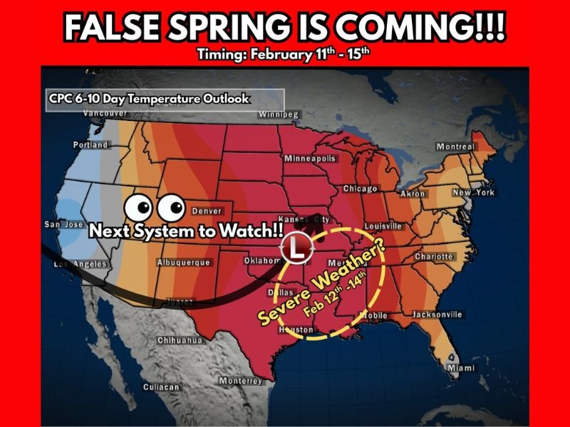
What the Temperature Outlook Is Signaling for Feb. 11–15
A national 6–10 day temperature outlook indicates widespread above-normal temperatures building from the central U.S. into the South and portions of the East. In the Southeast, that warmer air includes Georgia, South Carolina, and North Carolina, which can push daytime readings higher than what many people expect for mid-February — a classic setup for “false spring” conditions.
Warmth this time of year can feel like a break from winter, but it also increases the atmosphere’s ability to hold moisture when a storm system approaches.
Where the Next Storm System Could Organize
The data highlights a “next system to watch” developing out of the central U.S., with a low-pressure track that could draw moisture from the Gulf. The most emphasized storm zone right now sits over Texas into the lower Mississippi Valley, where warmer air and incoming moisture can support heavier rain and stronger thunderstorms if the system times out correctly.
Feb. 12–14: Why Texas, Louisiana, Mississippi and Alabama Are the Focus
The current signal puts the greatest “watch zone” for a possible severe-weather setup across Texas, Louisiana, Mississippi, and Alabama from Feb. 12–14. That does not guarantee severe storms — but it’s an early heads-up that ingredients may come together for a more active round of weather than typical winter rain.
If stronger storms develop, the main concerns usually include damaging wind gusts, isolated tornado potential, and localized flooding in areas that get repeated downpours.
What This Could Mean for Georgia, South Carolina and North Carolina
While the highest storm emphasis is west of the Carolinas, Georgia, South Carolina, and North Carolina are still part of the broader warm pattern. That means any approaching system later in the period could arrive with a warmer, more humid air mass than usual, increasing the potential for heavier rainfall and stronger storms if the track shifts east.
What To Watch Next
Key details still need to sharpen, including the storm track, timing, and how quickly Gulf moisture returns. If you’re in the Southeast, the smart move is to treat this as an early alert: warmer air is building, and the next system may have more energy than a typical winter rainmaker.
If you’re seeing unusually warm afternoons or hearing thunder in your area later next week, send us what you’re noticing — and keep checking SaludaStandard-Sentinel.com for updated timing and state-by-state impacts.