Texas, Louisiana, Mississippi, Alabama, Georgia, and South Carolina Could See Valentine’s Day Severe Storm Outbreak as Models Align
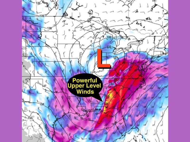
UNITED STATES — Forecast graphics circulating ahead of Valentine’s Day show a storm setup that meteorologists often flag as “high impact,” with powerful upper-level winds and a deepening low pressure system that could support a multi-state severe weather outbreak stretching from Texas and Louisiana into Mississippi, Alabama, Georgia, and toward South Carolina.
Why Forecasters Are Watching This Pattern Closely
The data highlights a strong, energetic trough and a pronounced low (“L”) pulling the atmosphere into a more volatile configuration. When upper-level winds strengthen like this, they can provide the lift and wind shear needed for organized storms—especially if warm, humid air is able to surge north out of the Gulf.
In plain terms: the engine is there, and if the fuel lines up, storms can quickly become widespread and intense.
Where the Storm Line Could Set Up in Texas and Louisiana
Model guidance shown in the images suggests a consolidated line of storms developing in Texas and pushing east toward Louisiana, with the potential for heavy rain, lightning, and damaging wind gusts along and ahead of the main boundary.
This is the phase where storms can rapidly grow in coverage, particularly during the afternoon and evening if instability builds.
Mississippi, Alabama, and Georgia Could Be Next in Line
As the system lifts northeast, the same setup can translate into a more active severe threat across Mississippi and Alabama, extending into Georgia. With strong winds aloft, storms that form in this corridor can organize into squall lines or broken lines of rotating storms, depending on timing and how the warm sector evolves.
Even in scenarios where tornado risk is isolated, the combination of wind energy and storm coverage can still create widespread damage from straight-line winds.
What This Could Mean for South Carolina and the Southeast
While the most concentrated storm line in the model images appears farther west, the broader pattern suggests the severe-weather window could expand east into parts of the Southeast. For South Carolina, that often means watching for storms arriving later, with the main threats typically shifting to damaging wind gusts, fast-moving storm lines, and isolated spin-up tornado potential if conditions remain favorable.
What to Do Now Before Valentine’s Day
With both major models showing a similar “organized” storm signal, the key right now is preparation and awareness—especially because fast-moving severe events can unfold overnight when people are least likely to receive warnings quickly.
Have storms disrupted your Valentine’s Day plans before, or are you already preparing for this setup? Share what you’re seeing in your area and keep up with updates at SaludaStandard-Sentinel.com.