Texas, Louisiana, Mississippi, Alabama and Georgia Could See Late-April Cold Blast as GFS Model Signals Feels-Like Temperatures Falling Into 20s and 30s Around April 16
UNITED STATES — A long-range weather model is signaling a potential late-April cold blast that could send temperatures plunging across parts of the southern United States, including areas along the Gulf Coast.
The projected pattern around April 16 suggests an unusual surge of colder-than-normal air pushing deep into regions that typically experience mild spring conditions, raising the possibility of a brief but noticeable return to winter-like chill.
GFS Model Highlights Unusual Cold Spread Across the South
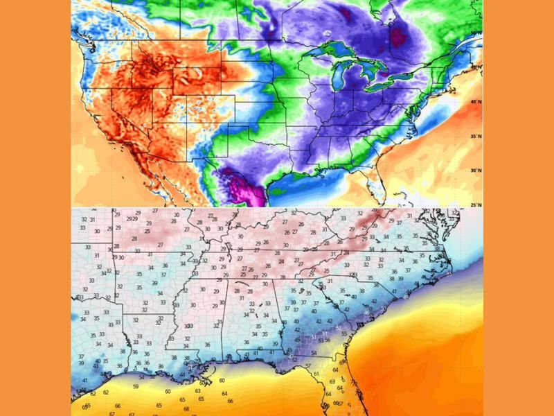
Forecast data from the GFS model shows a wide area of below-average temperatures expanding across much of the eastern and southern United States.
The anomaly map indicates cooler air spreading from the central Plains into the Deep South and stretching toward the Gulf Coast. This type of pattern is not typical for mid-April, when temperatures are usually trending warmer. However, this remains a long-range projection, meaning details could still shift as newer model runs refine the outlook.
Feels-Like Temperatures Could Drop Into 20s and 30s
One of the more striking aspects of this potential setup is how cold it could feel, especially when wind is factored in.
Projected “feels-like” temperatures suggest readings could dip into the upper 20s, 30s, and low 40s across several inland areas. Gusty winds could make conditions feel even colder than the actual air temperature.
This type of chill would be a sharp contrast to typical April weather, potentially catching many off guard if the pattern holds.
Gulf Coast May Avoid the Worst of the Cold Air
While inland areas could experience the brunt of the cold, coastal regions along the Gulf may remain somewhat moderated by warmer sea surface temperatures.
This could create a noticeable temperature contrast between inland cities and coastal areas, where conditions may feel less severe despite the broader cold pattern. Still, even coastal regions could see cooler-than-normal conditions compared to seasonal averages.
Why This Pattern Is Getting Attention Despite Uncertainty
The reason this setup is drawing attention is the scale and intensity of the cold anomaly being shown in current projections.
Even though it is still early and subject to change, patterns like this can sometimes signal significant short-term cold snaps when they appear consistently in model guidance. Meteorological patterns in spring can shift quickly, so confidence will increase as the timeframe gets closer.
What Residents Should Watch in the Coming Days
With this being a long-range outlook, the most important step is to monitor updates as the forecast evolves. If the pattern holds, residents across parts of Texas, Louisiana, Mississippi, Alabama, and Georgia may need to prepare for a temporary return to colder conditions.
For now, this serves as an early signal rather than a confirmed forecast, but one that could have noticeable impacts if it materializes. As this unusual April pattern develops, are you ready for a possible return of colder air? Share your thoughts and preparations with us at SaludaStandard-Sentinel.com.