Texas, Louisiana, Mississippi, Alabama and Florida Face Rising Severe Weather Risk in Early April as Pattern Intensifies
GULF COAST UNITED STATES — Forecast data is signaling a noticeable shift toward a more active and potentially severe weather pattern across Texas, Louisiana, Mississippi, Alabama, and parts of Florida as early April approaches.
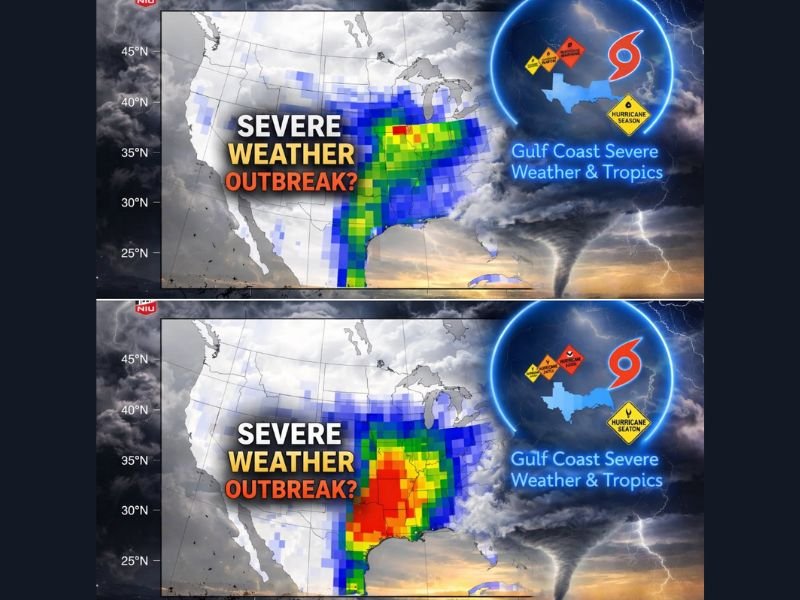
The latest outlook comparing late March into early April shows a clear escalation, with conditions becoming significantly more favorable for organized severe storms during the second week of the forecast period.
Week 2 Starts Quiet but Uncertain
From March 30 through April 5, the pattern appears relatively modest across the Gulf Coast and Deep South.
Forecast models suggest only limited storm activity, with scattered thunderstorm chances and weaker instability across the region. While not completely quiet, this period does not show strong signals for widespread severe weather.
This phase reflects a transitional setup, where the atmosphere is beginning to shift but has not yet fully developed into a more aggressive pattern.
Week 3 Shows Stronger Severe Weather Signals
Between April 6 and April 12, the forecast changes notably.
The map highlights a much more intense zone of activity expanding across:
- Texas
- Louisiana
- Mississippi
- Alabama
- Western Florida Panhandle
This region shows stronger instability, increased Gulf moisture, and enhanced wind shear — all key ingredients needed for severe thunderstorms.
Ingredients Aligning for Potential Outbreak
Several atmospheric factors appear to be coming together during this period. Moisture from the Gulf of Mexico is expected to surge northward, increasing humidity levels across the Deep South. At the same time, strengthening wind shear and rising instability could create an environment supportive of organized storm systems.
These setups are often associated with hazards such as:
- Damaging winds
- Large hail
- Tornado potential
While specific storm details are not yet clear, the overall pattern is one that typically supports stronger storm development.
Core Risk Focused Along the Gulf Coast and Deep South
The most concentrated risk appears centered over eastern Texas through Mississippi and Alabama, where the deepest moisture and strongest dynamics overlap.
Louisiana sits directly within this corridor, making it one of the key areas to watch as the pattern evolves. Farther east into Florida, especially the Panhandle, the risk appears more conditional but still within the broader zone of concern.
Still Too Early for Exact Timing
Despite the strong signals, this forecast remains several days out, meaning changes are still possible. The exact timing of storms, specific high-risk days, and the most impacted locations will become clearer as newer data comes in closer to early April.
At this stage, the outlook should be viewed as an early warning of a potentially more active period rather than a confirmed severe event.
A Pattern Shift Worth Watching
This setup represents a shift away from quieter late-March conditions toward a more dynamic spring pattern. Early April is often a time when severe weather begins to ramp up across the Gulf Coast and Deep South, and current signals suggest that trend may be developing again.
Residents across Texas, Louisiana, Mississippi, Alabama, and Florida should stay alert for updates as this pattern continues to evolve.
Are you in the Gulf Coast region and preparing for a more active weather stretch, or do you think this system will weaken before it arrives? Share your thoughts with us at SaludaStandard-Sentinel.com.