Texas, Louisiana, Mississippi, Alabama, and Florida Could See Wintry Precipitation Around January 19 as GFS Model Signals Gulf Coast Cold Setup
SOUTHERN UNITED STATES — A recent overnight run of the Global Forecast System (GFS) model is drawing attention among forecasters after signaling a potential wintry setup across portions of Texas, Louisiana, Mississippi, Alabama, and northern Florida around January 19. While the scenario remains several days away and is not locked in, the shift in timing and structure has made the signal more noticeable than earlier long-range projections.
GFS Model Brings Cold and Moisture Into the Gulf Coast Region
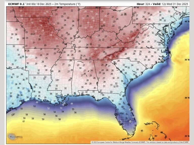
According to the latest data, the GFS model shows cold air pressing southward while Gulf moisture moves inland, a combination that can support freezing rain, sleet, or light snow if temperatures remain low enough at the surface. This type of setup is particularly sensitive to small temperature changes, which means outcomes can vary significantly even within short distances.
The model no longer places this system two weeks out, instead moving it into the 10-day window, which typically increases meteorological interest while still leaving room for major changes.
Why the January 19 Timeline Matters
Forecast confidence generally increases as systems move closer in time. While a 10-day outlook does not confirm impacts, it often represents the range where meteorologists begin closer monitoring rather than dismissal. At this stage, the signal is plausible but unconfirmed, meaning it warrants attention without prompting immediate preparation or concern.
Typical Forecast Confidence Progression for Winter Systems
Long-range winter forecasts often follow a predictable pattern of evaluation:
- 14 days out: Considered too distant for reliability
- 10 days out: Noted, but treated cautiously
- 7 days out: Pattern begins to matter
- 5 days out: Details start forming
- 3 days out: Preparations may be advised if confidence increases
This current setup remains in the early observation phase.
What This Forecast Does Not Confirm Yet
The data does not confirm exact precipitation types, accumulation amounts, or specific impact zones. It also does not guarantee that freezing temperatures will align perfectly with available moisture. A small shift in storm track or temperature profile could result in cold rain instead of ice or snow. Because of these uncertainties, residents across the Gulf Coast should view this as a pattern to monitor, not a finalized forecast.
Potential Impacts If Conditions Align
If the colder scenario shown by the GFS were to develop as depicted, possible impacts could include:
- Light icing on bridges and elevated roadways
- Isolated travel disruptions
- Power interruptions in localized areas
- Cold-weather stress on infrastructure and agriculture
These outcomes depend heavily on how temperatures evolve closer to the event.
What Residents Should Do Now
At this stage, no action is required beyond staying informed. Winter weather events in the Gulf Coast region often develop quickly, and clarity typically improves within a few days of the projected timeframe.
Saluda Standard-Sentinel will continue tracking this developing pattern and provide updates as confidence increases. Readers are encouraged to follow ongoing coverage and share how winter weather affects their communities by staying connected with SaludaStandard-Sentinel.com.