Texas Forecast to See Strong 40–50 mph Wind Gusts Wednesday Morning as Weak Front Brings Widespread Blowing Debris Across the DFW Region
TEXAS — A windy Wednesday is ahead for much of North Texas, with forecast data showing gusts between 40 and 50 mph spreading across the Dallas–Fort Worth region during the morning hours. Though temperatures will not change significantly, meteorologists warn that the gusty conditions will be highly noticeable, creating challenges for outdoor items, holiday decorations, and travel.
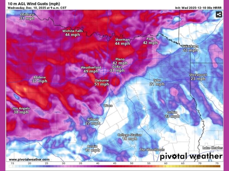
Strongest Gusts Expected Across DFW and Surrounding Areas
According to the latest HRRR model, several cities are projected to see wind gusts reach or exceed 45 mph, including:
• Cleburne — 51 mph
• Weatherford — 49 mph
• Wichita Falls — 44 mph
• Sherman — 44 mph
• Plano — 42 mph
• Dallas — 31–42 mph depending on timing
• Paris — 42 mph
Farther west, Abilene and San Angelo will see gusts near 37–38 mph, while central and eastern areas such as Waco, Tyler, and Lufkin may experience gusts between 18 and 23 mph.
These gusts fall well within the range known to move unsecured items, sway high-profile vehicles, and cause scattered minor disruptions.
Holiday Decorations and Trash Bins Most at Risk
With Christmas inflatables and yard displays now in full setup across Texas neighborhoods, residents should be prepared for:
• Inflatable decorations becoming airborne
• Trash bins tipping over or rolling into streets
• Lawn debris blowing across yards and sidewalks
• Lightweight patio items shifting or falling
Some communities could see wind-driven “trash can races” early Wednesday, with bins rolling down streets as gusts peak around 9–11 AM.
Travel Impacts Possible for High-Profile Vehicles
Drivers operating vans, delivery trucks, RVs, or trailers may notice difficulty maintaining lanes along:
• I-20
• I-30
• I-35 and I-35E
Open stretches west of Fort Worth and north of Dallas will experience the strongest crosswinds.
Meteorologists emphasize that while the winds are not severe storm-level, they are powerful enough to affect travel and daily routines, particularly during the morning commute.
Conditions Expected to Improve by Afternoon
The strongest winds are forecast to weaken gradually after midday as the weak front progresses through the region. By mid-afternoon, wind gusts should drop below 20–25 mph for most Texas cities.
Still, residents across Texas—especially in the DFW corridor—are encouraged to secure outdoor items before Wednesday morning to prevent damage or loss.
Stay connected with the Saluda Standard-Sentinel Team for additional weather updates and safety guidance at SaludaStandard-Sentinel.com.