Texas Faces Four-Day Severe Storm Threat From Amarillo and Lubbock to Dallas and San Antonio With Repeated Risk Through Early Next Week
TEXAS — A prolonged stretch of active weather is expected to impact large portions of Texas, with multiple days of severe storm potential developing from the Panhandle down through central and south-central parts of the state.
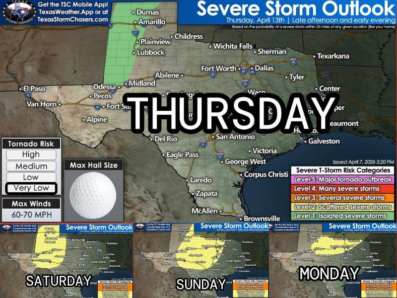
The setup highlights a four-day window of concern, with storms possible from Thursday through early next week, signaling a sustained period of instability across the region.
Severe Weather Threat Begins Thursday Across North and West Texas
The first round of storm activity is expected to develop Thursday, particularly across parts of north and west Texas, including areas near Amarillo, Lubbock, Midland, and Abilene.
Storms forming in this region could bring hail and gusty winds as the atmosphere becomes increasingly unstable during the late afternoon and evening hours. Cities farther east, including Dallas-Fort Worth, may also see storm activity depending on how systems evolve through the day.
Weekend Storm Chances Expand Across Central Texas
By Saturday and Sunday, the severe weather risk is expected to expand across a broader portion of the state, including central Texas and areas stretching toward Austin, San Antonio, and surrounding communities.
These days may bring more widespread storm coverage, with repeated rounds of showers and thunderstorms possible. While not every location will experience severe conditions, the repeated nature of storms increases the potential for stronger cells to develop.
Continued Risk Into Early Next Week
The pattern does not end with the weekend. Forecast data indicates that storm chances may continue into Monday, extending the period of concern.
This extended timeline suggests that Texas could see multiple waves of storm activity, rather than a single isolated event. As systems move across the state, conditions may vary day to day, making it important for residents to stay alert to changing forecasts.
Large Hail and Strong Storms Possible
One of the primary concerns during this multi-day event is the potential for hail, with some storms capable of producing larger hailstones. In addition to hail, strong winds and localized heavy rainfall may accompany stronger storm cells.
While widespread severe outbreaks are not guaranteed, isolated strong storms remain a possibility throughout this period.
Active Spring Pattern Driving Ongoing Storm Risks
This setup is consistent with a typical springtime pattern, where shifting systems and warm air create favorable conditions for thunderstorms.
The repeated storm chances reflect a broader active weather trend, which may continue to bring periodic severe weather risks beyond this forecast window. Residents across Texas should remain prepared as the pattern continues to evolve.
Preparedness Key During Multi-Day Event
With several days of storm potential ahead, preparedness becomes especially important. Monitoring daily forecasts, having a plan in place, and staying aware of changing weather conditions can help reduce risks during this active period.
Even if storms are not severe in every area, conditions can shift quickly. Are you preparing for this extended stretch of stormy weather in Texas? Share how you’re getting ready at SaludaStandard-Sentinel.com.