Texas, Arkansas, Louisiana, Mississippi, Tennessee, Kentucky, Illinois and Indiana Enter Early April Severe Weather Zone as Pattern Shift Signals Multi-Day Storm Threat
UNITED STATES — A developing weather pattern change is signaling the return of active severe weather across a large portion of the central United States as the calendar turns to April, with multiple storm systems expected to impact the region during the first week of the month.
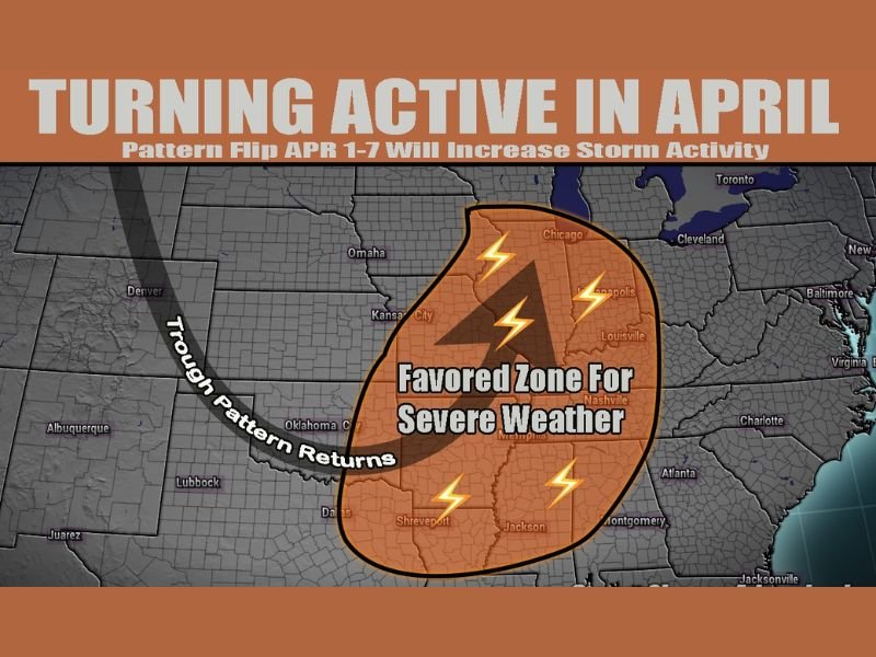
Forecasters are increasingly focused on a broad corridor stretching from Texas northeast through the Mississippi Valley into Indiana, where conditions may favor repeated rounds of strong to severe thunderstorms.
Pattern Shift Signals More Active Storm Setup
Forecast data for the 7–10 day period indicates a notable shift in the overall weather pattern, transitioning from quieter conditions into a more energized setup capable of producing multiple storm systems.
This type of pattern typically allows disturbances to track across the central U.S., tapping into Gulf moisture and interacting with warmer spring air — a combination that often fuels severe weather outbreaks.
The early April timeframe, particularly between April 1 and April 7, is now being closely monitored for this transition.
Mississippi Valley Emerges as Primary Target Zone
Current projections highlight the Mississippi Valley as the most favored region for severe weather development.
This includes parts of northeast Texas, Arkansas, Louisiana, Mississippi, western and middle Tennessee, Kentucky, southern Illinois, and Indiana.
Major cities such as Dallas, Shreveport, Jackson, Memphis, Nashville, Louisville, St. Louis, and Indianapolis fall within this broader zone, though exact hotspots will depend on how each storm system evolves.
Multiple Rounds of Storms Possible
Unlike a single-day event, this setup is expected to unfold over several days, increasing the risk of repeated impacts across the same areas.
Each passing system could bring its own round of thunderstorms, meaning some locations may face multiple opportunities for severe weather within a short window.
This kind of multi-day pattern can raise concerns for cumulative impacts, including saturated ground and heightened storm intensity.
Severe Weather Threats Could Increase
While it is still too early to determine specific storm timing or intensity, the overall environment suggests the potential for classic springtime severe weather hazards.
These may include damaging winds, large hail, heavy rainfall, and the possibility of tornadoes if atmospheric conditions align. The combination of warm air, increasing humidity, and favorable wind patterns will be key factors in determining how severe each round becomes.
Forecast Uncertainty Still Remains
Despite growing confidence in an active pattern, there is still variability in where the most intense storms will occur within the broader risk zone.
Small shifts in storm tracks, temperature gradients, or moisture levels can significantly impact which areas see the highest threat. As a result, residents across the highlighted states should stay tuned for more detailed forecasts as the timeframe gets closer.
What to Expect in the Days Ahead
As April approaches, forecast models will begin to refine the timing and placement of each storm system. Emergency officials and meteorologists will likely provide more specific guidance regarding potential severe weather days and impacted regions.
Residents are encouraged to review safety plans early and remain weather-aware, especially if living in areas historically prone to spring severe weather.
If you’re located anywhere from Texas through the Mississippi Valley into Indiana, share your thoughts and stay updated with the latest developments on SaludaStandard-Sentinel.com.